IMAGES TAKEN NEAR TO
Kingshill, BIGGLESWADE, SG18 9DR
Introduction
This page details the photographs taken nearby to Kingshill, SG18 9DR by members of the Geograph project.
The Geograph project started in 2005 with the aim of publishing, organising and preserving representative images for every square kilometre of Great Britain, Ireland and the Isle of Man.

There are currently over 7.5m images from over14,400 individuals and you can help contribute to the project by visiting https://www.geograph.org.uk
Image Map
Images are licensed for reuse under creativecommons.org/licenses/by-sa/2.0
Notes
- Clicking on the map will re-center to the selected point.
- The higher the marker number, the further away the image location is from the centre of the postcode.
Image Listing (5 Images Found)
Images are licensed for reuse under creativecommons.org/licenses/by-sa/2.0
Image
Details
Distance
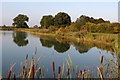

3
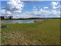
Restored sand & gravel pit workings at Broom
Most sand & gravel extraction workings now have to submit plans for restoration work after the quarrying has finished; very often, as here, those plans will result in the creation of a series of pools and lakes for fishing, wildlife habitat and recreation.
Image: © Richard Law
Taken: 11 Apr 2012
0.14 miles
4
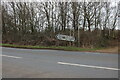
Direction signs on the B658, Upper Caldecote
Image: © David Howard
Taken: 30 Jan 2022
0.24 miles