IMAGES TAKEN NEAR TO
Bantock Way, BIGGLESWADE, SG18 8UQ
Introduction
This page details the photographs taken nearby to Bantock Way, SG18 8UQ by members of the Geograph project.
The Geograph project started in 2005 with the aim of publishing, organising and preserving representative images for every square kilometre of Great Britain, Ireland and the Isle of Man.

There are currently over 7.5m images from over14,400 individuals and you can help contribute to the project by visiting https://www.geograph.org.uk
Image Map
Images are licensed for reuse under creativecommons.org/licenses/by-sa/2.0
Notes
- Clicking on the map will re-center to the selected point.
- The higher the marker number, the further away the image location is from the centre of the postcode.
Image Listing (10 Images Found)
Images are licensed for reuse under creativecommons.org/licenses/by-sa/2.0
Image
Details
Distance
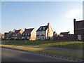
1
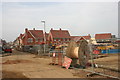
Building in progress, Penrose Park, Biggleswade
Image: © David Kemp
Taken: 8 Mar 2014
0.12 miles

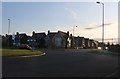
5
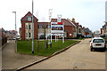
Maunder Avenue, Biggleswade
Maunder Avenue is part of the Penrose Park development which started to be occupied in late 2012.
Image: © David Kemp
Taken: 8 Mar 2014
0.14 miles
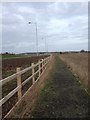
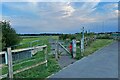
8
Bridleway towards West Sunderland Farm
Image: © Philip Jeffrey
Taken: 16 Sep 2023
0.21 miles
9
Penrose Park housing development, Biggleswade
These began completion in 2016
Image: © David Howard
Taken: 22 Aug 2019
0.22 miles
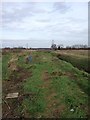
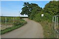
10
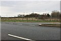
Baden Powell Way, Biggleswade
Running around the eastern edge of town.
Image: © David Howard
Taken: 8 Jan 2023
0.22 miles