IMAGES TAKEN NEAR TO
Fen Reach, BIGGLESWADE, SG18 8RZ
Introduction
This page details the photographs taken nearby to Fen Reach, SG18 8RZ by members of the Geograph project.
The Geograph project started in 2005 with the aim of publishing, organising and preserving representative images for every square kilometre of Great Britain, Ireland and the Isle of Man.

There are currently over 7.5m images from over14,400 individuals and you can help contribute to the project by visiting https://www.geograph.org.uk
Image Map
Images are licensed for reuse under creativecommons.org/licenses/by-sa/2.0
Notes
- Clicking on the map will re-center to the selected point.
- The higher the marker number, the further away the image location is from the centre of the postcode.
Image Listing (35 Images Found)
Images are licensed for reuse under creativecommons.org/licenses/by-sa/2.0
Image
Details
Distance


7
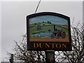
Dunton village sign (close-up)
See http://www.geograph.org.uk/photo/4290716 for a wider view
Image: © Bikeboy
Taken: 22 Dec 2014
0.16 miles
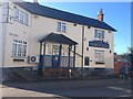
8
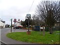
Dunton village sign
In the background is the pub, the March Hare. See http://www.geograph.org.uk/photo/4290726 for a close up.
Image: © Bikeboy
Taken: 22 Dec 2014
0.16 miles