IMAGES TAKEN NEAR TO
Church Street, BIGGLESWADE, SG18 8RR
Introduction
This page details the photographs taken nearby to Church Street, SG18 8RR by members of the Geograph project.
The Geograph project started in 2005 with the aim of publishing, organising and preserving representative images for every square kilometre of Great Britain, Ireland and the Isle of Man.

There are currently over 7.5m images from over14,400 individuals and you can help contribute to the project by visiting https://www.geograph.org.uk
Image Map
Images are licensed for reuse under creativecommons.org/licenses/by-sa/2.0
Notes
- Clicking on the map will re-center to the selected point.
- The higher the marker number, the further away the image location is from the centre of the postcode.
Image Listing (43 Images Found)
Images are licensed for reuse under creativecommons.org/licenses/by-sa/2.0
Image
Details
Distance
1

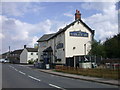
Church Street, Dunton
Looking south-eastward.
Image: © Peter Wood
Taken: 10 Oct 2021
0.01 miles

4
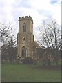
St Mary Magdalene, Dunton
The tower was built in 1861. The rest of the church is medieval and is mainly built of brown cobbles. These are smallish rounded stones of various types formed when existing rocks were broken up in the last ice age and then transported by torrential meltwaters.
Image: © David Kemp
Taken: 28 Nov 2007
0.02 miles
5
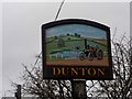
Dunton village sign (close-up)
See http://www.geograph.org.uk/photo/4290716 for a wider view
Image: © Bikeboy
Taken: 22 Dec 2014
0.02 miles
6
Dunton village sign
In the background is the pub, the March Hare. See http://www.geograph.org.uk/photo/4290726 for a close up.
Image: © Bikeboy
Taken: 22 Dec 2014
0.02 miles
7
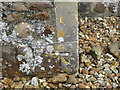
Ordnance Survey Cut Mark
This mark can be found on the wall of St Mary's Church, Dunton.
The recorded details give a height of 53.7027 metres above sea level.
For more details see : https://www.bench-marks.org.uk/bm31766
Image: © Peter Wood
Taken: 10 Oct 2021
0.03 miles
8
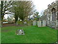
St Mary Magdalene, Dunton, Graveyard
Image: © Alexander P Kapp
Taken: 4 Feb 2013
0.03 miles
9
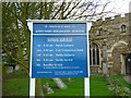
St Mary Magdalene, Dunton, Nameboard
Image: © Alexander P Kapp
Taken: 4 Feb 2013
0.03 miles
10
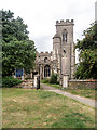
Dunton : Church of St Mary
Grade II* listed - https://historicengland.org.uk/listing/the-list/list-entry/1114060?section=official-list-entry.
Image: © Jim Osley
Taken: 6 Jul 2022
0.03 miles