IMAGES TAKEN NEAR TO
Lawrence Road, BIGGLESWADE, SG18 0LR

Introduction

This page details the photographs taken nearby to Lawrence Road, SG18 0LR by members of the Geograph project.

The Geograph project started in 2005 with the aim of publishing, organising and preserving representative images for every square kilometre of Great Britain, Ireland and the Isle of Man.

There are currently over 7.5m images from over14,400 individuals and you can help contribute to the project by visiting https://www.geograph.org.uk

Image Map


Images are licensed for reuse under creativecommons.org/licenses/by-sa/2.0
Notes
  • Clicking on the map will re-center to the selected point.
  • The higher the marker number, the further away the image location is from the centre of the postcode.

Image Listing (49 Images Found)

Images are licensed for reuse under creativecommons.org/licenses/by-sa/2.0
  • ...
Image
Details
Distance
1
Biggleswade: Lawrence Road & The Wheatsheaf public house
Victorian terraced housing.
Image: © Nigel Cox Taken: 11 Nov 2007
0.08 miles
2
Biggleswade: Gardeners Arms public house
This is a Greene King outlet on Potton Road.
Image: © Nigel Cox Taken: 11 Nov 2007
0.13 miles
3
Biggleswade fire station
Biggleswade fire station, Chestnut Avenue, Biggleswade, Bedfordshire
Image: © Kevin Hale Taken: 7 Oct 2007
0.13 miles
4
Biggleswade, Asda
Superstore off Church Street. https://storelocator.asda.com/store/biggleswade
Image: © Mike Faherty Taken: 27 Nov 2017
0.17 miles
5
Biggleswade : Stratton House
Grade II listed building currently in use as a hotel - https://historicengland.org.uk/listing/the-list/list-entry/1114480?section=official-list-entry. More on the history of the building at this https://www.biggleswadehistory.org.uk/research/places/stratton-house/.
Image: © Jim Osley Taken: 8 Apr 2022
0.17 miles
6
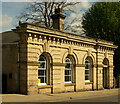
Biggleswade : former Court building
Grade II listed : description at this https://historicengland.org.uk/listing/the-list/list-entry/1321420?section=official-list-entry.
Image: © Jim Osley Taken: 8 Apr 2022
0.17 miles
7
Plaque on the County Court House
Placed in 2003, this plaque gives the history of the Image
Image: © Tiger Taken: 1 Oct 2015
0.17 miles
8
County Court House
In the High Street next to the bridge over the railway, Pevsner and O'Brien note this as "Italianate, single-storey with four round arches. All in brick, the ends with channelled rustication and a bracketed cornice along the top." A plaque placed by the Biggleswade History Society in 2003 tells us that: "Fredrick [sic] Hooper, solicitor and registrar, opened the building circa 1861 for use as a County Court for civil cases and offices for his solicitor's practice next door at Brigham House. Customs & Excise later used the building before it became the Job Centre. The building is now a private house." See Image
Image: © Tiger Taken: 1 Oct 2015
0.17 miles
9
Pathway to The Baulk
This short pathway takes pedestrians from the end of Lawnside back to The Baulk, in Biggleswade.
Image: © John Winder Taken: 30 Nov 2014
0.18 miles
10
Biggleswade : "The Rose" public house
Image: © Jim Osley Taken: 8 Apr 2022
0.19 miles
  • ...