IMAGES TAKEN NEAR TO
Torquay Close, BIGGLESWADE, SG18 0FS
Introduction
This page details the photographs taken nearby to Torquay Close, SG18 0FS by members of the Geograph project.
The Geograph project started in 2005 with the aim of publishing, organising and preserving representative images for every square kilometre of Great Britain, Ireland and the Isle of Man.

There are currently over 7.5m images from over14,400 individuals and you can help contribute to the project by visiting https://www.geograph.org.uk
Image Map
Images are licensed for reuse under creativecommons.org/licenses/by-sa/2.0
Notes
- Clicking on the map will re-center to the selected point.
- The higher the marker number, the further away the image location is from the centre of the postcode.
Image Listing (16 Images Found)
Images are licensed for reuse under creativecommons.org/licenses/by-sa/2.0
Image
Details
Distance
5
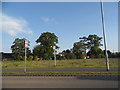
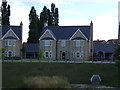
Baden Powell Way, Biggleswade
This is part of a new housing estate which is half completed on the east side of Biggleswade.
Image: © David Howard
Taken: 21 May 2018
0.15 miles
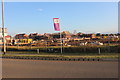
6
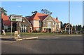
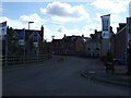
The King's Reach pub, Biggleswade
This has only just been finished and was built on a field.
Image: © David Howard
Taken: 22 Aug 2019
0.15 miles
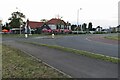
8
The King's Reach pub, Biggleswade
This has only just been finished and was built on a field.
Image: © David Howard
Taken: 22 Aug 2019
0.16 miles
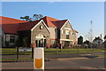
9
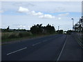
Large housing estate under construction on Baden Powell Way
Image: © David Howard
Taken: 22 Aug 2019
0.18 miles
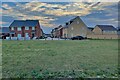
10
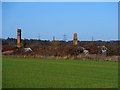
Derelict green houses and chimneys near to Biggleswade Hospital
Image: © Bikeboy
Taken: 2 Jan 2014
0.18 miles