IMAGES TAKEN NEAR TO
Maple Close, BIGGLESWADE, SG18 0EE
Introduction
This page details the photographs taken nearby to Maple Close, SG18 0EE by members of the Geograph project.
The Geograph project started in 2005 with the aim of publishing, organising and preserving representative images for every square kilometre of Great Britain, Ireland and the Isle of Man.

There are currently over 7.5m images from over14,400 individuals and you can help contribute to the project by visiting https://www.geograph.org.uk
Image Map
Images are licensed for reuse under creativecommons.org/licenses/by-sa/2.0
Notes
- Clicking on the map will re-center to the selected point.
- The higher the marker number, the further away the image location is from the centre of the postcode.
Image Listing (10 Images Found)
Images are licensed for reuse under creativecommons.org/licenses/by-sa/2.0
Image
Details
Distance

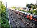
2
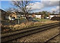
View from a Peterborough-London train - Beech Avenue, Biggleswade
Image: © Nigel Thompson
Taken: 7 Feb 2017
0.06 miles
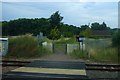
3

Biggleswade
From the late running 10:35 NXEC from Doncaster to London Kings Cross.
Image: © Steve Fareham
Taken: 8 Jul 2008
0.08 miles
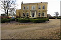
4
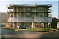
Renovations on Furzenhall Road
A 1960s apartment block on the edge of Biggleswade receives some attention.
Image: © John Winder
Taken: 30 Nov 2014
0.20 miles
5
East coast main line, Biggleswade, Beds
View N from the Potton Road bridge of a King's Cross-bound express.
Image: © Rodney Burton
Taken: 10 May 2006
0.21 miles
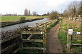
7
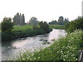
The River Ivel at Biggleswade, Beds
view downstream from below the Hill Lane bridge.
Image: © Rodney Burton
Taken: 9 May 2006
0.23 miles