IMAGES TAKEN NEAR TO
Churchill Way, SHEFFORD, SG17 5UB
Introduction
This page details the photographs taken nearby to Churchill Way, SG17 5UB by members of the Geograph project.
The Geograph project started in 2005 with the aim of publishing, organising and preserving representative images for every square kilometre of Great Britain, Ireland and the Isle of Man.

There are currently over 7.5m images from over14,400 individuals and you can help contribute to the project by visiting https://www.geograph.org.uk
Image Map
Images are licensed for reuse under creativecommons.org/licenses/by-sa/2.0
Notes
- Clicking on the map will re-center to the selected point.
- The higher the marker number, the further away the image location is from the centre of the postcode.
Image Listing (8 Images Found)
Images are licensed for reuse under creativecommons.org/licenses/by-sa/2.0
Image
Details
Distance
1
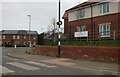
Roundabout on Ivel Road, Shefford
Oak Manor care home is on the right
Image: © David Howard
Taken: 30 Jan 2022
0.02 miles
2
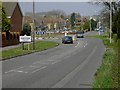
Entering Shefford from Meppershall direction
Image: © John Yaxley
Taken: 14 Apr 2007
0.03 miles


6

A507 approaching Shefford Road roundabout
Image: © Colin Pyle
Taken: 3 Jul 2011
0.14 miles