IMAGES TAKEN NEAR TO
Grieg Close, SHEFFORD, SG17 5SE
Introduction
This page details the photographs taken nearby to Grieg Close, SG17 5SE by members of the Geograph project.
The Geograph project started in 2005 with the aim of publishing, organising and preserving representative images for every square kilometre of Great Britain, Ireland and the Isle of Man.

There are currently over 7.5m images from over14,400 individuals and you can help contribute to the project by visiting https://www.geograph.org.uk
Image Map
Images are licensed for reuse under creativecommons.org/licenses/by-sa/2.0
Notes
- Clicking on the map will re-center to the selected point.
- The higher the marker number, the further away the image location is from the centre of the postcode.
Image Listing (25 Images Found)
Images are licensed for reuse under creativecommons.org/licenses/by-sa/2.0
Image
Details
Distance
1
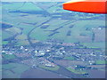
Shefford, seen from the air
On the downwind leg to Rwy26 at Luton airport. Thanks to John Webb for pointing out that the distinctive line running from top to bottom of the image is the line of the former Midland Railway from Leicester through Bedford to Hitchin. It was opened in 1857, but became a secondary line after the opening of the direct route in 1868 from Bedford to St Pancras, and was closed in 1962.
Image: © M J Richardson
Taken: 12 Dec 2014
0.06 miles
2
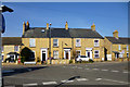
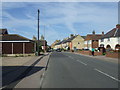
67 - 71 (odds) Clifton Road, Shefford
Three houses noticeably grander than the cottages to either side. Undated, but present on a map of 1881, when the wider house at the right had a through passage under in place of the window to the right of the door, which explains the rather different brickwork here.
Image: © Robin Webster
Taken: 13 Mar 2016
0.11 miles
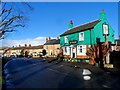
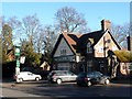
7
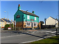
The Woolpack, Shefford
On the corner of Hitchin Road and Clifton Road.
Image: © Robin Webster
Taken: 13 Mar 2016
0.12 miles
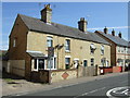
8
Chinese takeaway
On Clifton Road, Shefford.
Image: © JThomas
Taken: 22 Aug 2015
0.13 miles
9
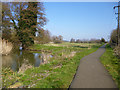
Former course of Ivel Navigation, Shefford
The natural course of the River Flit bends round to the left via a former mill, The navigation lock cut went straight on here, to the left of the now tarmac towpath. The lock was at the far end just before rejoining the river. There is now no trace of cut or lock which have been filled in or apparently dismantled.
Image: © Robin Webster
Taken: 13 Mar 2016
0.14 miles
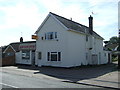
10
The Golden Lion, Clifton
Not the Golden Lion Clifton, M27 6PE (Greater Manchester).
Image: © Bikeboy
Taken: 2 Jan 2014
0.15 miles