IMAGES TAKEN NEAR TO
Maple Close, SHEFFORD, SG17 5QX
Introduction
This page details the photographs taken nearby to Maple Close, SG17 5QX by members of the Geograph project.
The Geograph project started in 2005 with the aim of publishing, organising and preserving representative images for every square kilometre of Great Britain, Ireland and the Isle of Man.

There are currently over 7.5m images from over14,400 individuals and you can help contribute to the project by visiting https://www.geograph.org.uk
Image Map
Images are licensed for reuse under creativecommons.org/licenses/by-sa/2.0
Notes
- Clicking on the map will re-center to the selected point.
- The higher the marker number, the further away the image location is from the centre of the postcode.
Image Listing (12 Images Found)
Images are licensed for reuse under creativecommons.org/licenses/by-sa/2.0
Image
Details
Distance
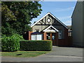
3
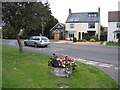
Clifton Chapel, Beds
View across Shefford Road of the Providence Baptist Church founded 1936.
Image: © Rodney Burton
Taken: 3 Oct 2005
0.05 miles
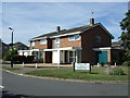
4
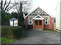
Providence Baptist Chapel, Shefford Road, Clifton
Dated 1936.
Image: © Humphrey Bolton
Taken: 30 Jan 2019
0.06 miles
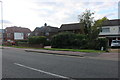
5
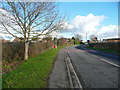
Shefford Road, Clifton
This was the A507 road.
Image: © Humphrey Bolton
Taken: 30 Jan 2019
0.08 miles
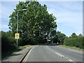
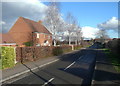
7
Spring Road, Clifton
A Home Watch Area, according to the yellow sign. I watched, but nothing exciting happened.
Image: © Robin Webster
Taken: 13 Mar 2016
0.11 miles
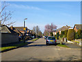
8

Pedley Lane, Clifton
Looking south-westward.
Image: © Peter Wood
Taken: 10 Oct 2021
0.14 miles