IMAGES TAKEN NEAR TO
Bedford Road, SHEFFORD, SG17 5NU
Introduction
This page details the photographs taken nearby to Bedford Road, SG17 5NU by members of the Geograph project.
The Geograph project started in 2005 with the aim of publishing, organising and preserving representative images for every square kilometre of Great Britain, Ireland and the Isle of Man.

There are currently over 7.5m images from over14,400 individuals and you can help contribute to the project by visiting https://www.geograph.org.uk
Image Map
Images are licensed for reuse under creativecommons.org/licenses/by-sa/2.0
Notes
- Clicking on the map will re-center to the selected point.
- The higher the marker number, the further away the image location is from the centre of the postcode.
Image Listing (5 Images Found)
Images are licensed for reuse under creativecommons.org/licenses/by-sa/2.0
Image
Details
Distance
1
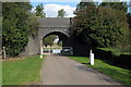
Disused railway bridge on the path to Bedford Road
Image: © Philip Jeffrey
Taken: 9 Sep 2014
0.15 miles
2
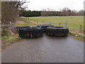
Track block
Some heavy plant tyres blocking a track towards Shefford Hardwicke.
Image: © Michael Trolove
Taken: 17 Mar 2013
0.16 miles
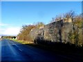
4
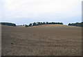
Farmland, Shefford, Beds
View N from the Bedford Road.
Image: © Rodney Burton
Taken: 13 Sep 2005
0.23 miles