IMAGES TAKEN NEAR TO
Bedford Road, SHEFFORD, SG17 5DJ
Introduction
This page details the photographs taken nearby to Bedford Road, SG17 5DJ by members of the Geograph project.
The Geograph project started in 2005 with the aim of publishing, organising and preserving representative images for every square kilometre of Great Britain, Ireland and the Isle of Man.

There are currently over 7.5m images from over14,400 individuals and you can help contribute to the project by visiting https://www.geograph.org.uk
Image Map
Images are licensed for reuse under creativecommons.org/licenses/by-sa/2.0
Notes
- Clicking on the map will re-center to the selected point.
- The higher the marker number, the further away the image location is from the centre of the postcode.
Image Listing (46 Images Found)
Images are licensed for reuse under creativecommons.org/licenses/by-sa/2.0
Image
Details
Distance
1
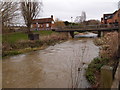
Water Course through Shefford
Becomes the River Ivel (navigation) disused after the bridge. So for a period in history a canal arm from the River Ivel proper was linked back to Shefford. Further reading http://www.canalroutes.net/Ivel-River.html
Image: © Michael Trolove
Taken: 17 Mar 2013
0.08 miles
2
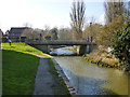
North Bridge and Northbridge Wharf, Shefford
This was the main terminus of the Ivel Navigation, with a public wharf. A branch to South Bridge was apparently used for traffic to a tannery. The navigation was formally abandoned in 1876 after some years of very little use. The locks on the navigation were 110' by 12', presumably to handle a pair of fen lighters, about 48' long by 10'-6" beam. Even allowing for the fact that the present bridge is a modern replacement, encroaching a little on the wharf area here, there seems no room to turn a lighter. I believe this was not necessary, as the lighters were double ended with no rudder, navigated in close coupled trains of at least two. They were steered by a man on one lighter manipulating a sort of tiller rigidly fixed to the other.
Image: © Robin Webster
Taken: 13 Mar 2016
0.08 miles
3
The Wharf on Northbridge Street, Shefford
By the River Ivel, no connection to the dairy related saint of the same name.
Image: © David Howard
Taken: 6 Sep 2020
0.09 miles
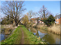
4
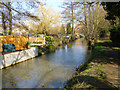
River Flit (former Ivel Navigation), Shefford
Looking downstream. The navigation used both the Rivers Flit and Hit for two short terminal branches in Shefford. This is the branch to the North Bridge limit of navigation about 80 m behind the camera, where the principal wharf was.
Image: © Robin Webster
Taken: 13 Mar 2016
0.12 miles
5
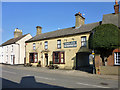
The Brewery Tap, Shefford
On Northbridge Street.
Image: © Robin Webster
Taken: 13 Mar 2016
0.14 miles
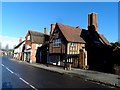
6
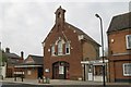
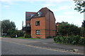
Shefford old fire station
Shefford old fire station, Northbridge Street, Shefford, Bedfordshire, is now used as council offices
Image: © Kevin Hale
Taken: 7 Oct 2007
0.16 miles
7
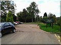
Parking area at the back of The White Hart, Shefford
Image: © Rob Purvis
Taken: 28 Sep 2013
0.17 miles
8
River Flit (former Ivel Navigation), Shefford
The navigation used both the Rivers Flit and Hit for two short terminal branches in Shefford. This is the branch to the North Bridge limit of navigation, where the principal wharf was.
Image: © Robin Webster
Taken: 13 Mar 2016
0.18 miles
9
16th Century building used as a Barclays bank branch
See http://www.heritagegateway.org.uk/Gateway/Results_Single.aspx?uid=1158117&resourceID=5 for a description.
Image: © Bikeboy
Taken: 22 Dec 2013
0.18 miles
10
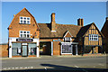
Beyond Beauty and Barclays Bank, Shefford
A grade II listed building, originally built in the 16th century as one house, reworked early 19th and 20th centuries. A rather puzzling shop front on the right, called 'The Porch Shefford' - if this is not the bank, where is it? Through the arch?
Image: © Robin Webster
Taken: 13 Mar 2016
0.18 miles