IMAGES TAKEN NEAR TO
Claymores, STEVENAGE, SG1 3TP
Introduction
This page details the photographs taken nearby to Claymores, SG1 3TP by members of the Geograph project.
The Geograph project started in 2005 with the aim of publishing, organising and preserving representative images for every square kilometre of Great Britain, Ireland and the Isle of Man.

There are currently over 7.5m images from over14,400 individuals and you can help contribute to the project by visiting https://www.geograph.org.uk
Image Map
Images are licensed for reuse under creativecommons.org/licenses/by-sa/2.0
Notes
- Clicking on the map will re-center to the selected point.
- The higher the marker number, the further away the image location is from the centre of the postcode.
Image Listing (10 Images Found)
Images are licensed for reuse under creativecommons.org/licenses/by-sa/2.0
Image
Details
Distance
2
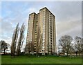
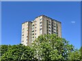
Harrow Court Stevenage
Harrow Court is an 18 storey tower block of flats (ground floor - 17th floor) located in the Bedwell area of Stevenage just outside Stevenage Town Centre next to Stevenage Town Gardens along Silam Road.
Built alongside its twin sister 18 storey tower block, Brent Court, in 1965. Both structures became the tallest buildings in Stevenage from 1965, however they are both soon to be overtaken by new build apartment blocks in Stevenage that will be up to 20 storeys in height, overtaking both Harrow Court and Brent Court by 3 storeys.
On Wednesday 2nd February 2005 a fire broke out on the 14th floor of Harrow Court which took the life of one resident and two fire fighters, every 2nd February each year Stevenage residents pay their respects to the firefighters and one resident that lost their lives in the 2005 fire.
Image: © Andy Steele
Taken: 4 Jan 2023
0.15 miles
3
King George’s Field Stevenage
Taken from the 17th Floor of Harrow Court.
King George’s Field is located just outside Stevenage Town Centre nearest to Stevenage Old Town.
Image: © Andy Steele
Taken: 11 Jun 2024
0.19 miles
4
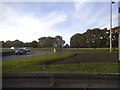
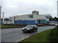
Roundabout on Fairlands Way, Stevenage
Image: © David Howard
Taken: 28 Sep 2017
0.20 miles
5
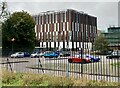
Autolus Stevenage
Located in Marshgate in Stevenage Town Centre.
Taken from a view just behind Stevenage Swimming Pool in the Town Centre Gardens showing the recently new build Science Block owned by Autolus.
This was one of the Regeneration Projects by Stevenage Borough Council however this included the loss of Marshgate Car Park.
Image: © Andy Steele
Taken: 19 Oct 2023
0.21 miles
6
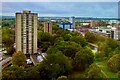
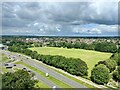
Stevenage Skyline - October 2023 (Harrow Court)
Taken from the 17th Floor of Harrow Court.
Overlooking the changes of Stevenage Town Centre, Harrow Court is one of the best buildings for photography of Stevenage as you can see the next village over being Watton At Stone 5 Miles South.
Image: © Andy Steele
Taken: 19 Oct 2023
0.21 miles
7
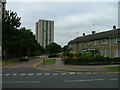
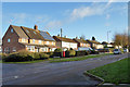
Silam Rd.
To the right are houses not untypical of Stevenage new town. Looming over Silam Rd is one of a pair of high rise flats close to the town centre.
Image: © Robin Hall
Taken: 21 Jul 2005
0.22 miles
8
Brent Court Stevenage
Built in 1965, an 18 Storey (Ground Floor - 17th Floor) Tower Block of Flats located in the Bedwell area of Stevenage in the Stevenage Town Gardens near Stevenage Town Centre.
Image: © Andy Steele
Taken: 26 May 2023
0.24 miles
9
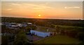
Stevenage Sunset (Brent Court)
A Orange Sunset taken from Brent Court in Stevenage, Hertfordshire on Monday 29th May 2023 at 8:45pm.
Image: © Andy Steele
Taken: 29 May 2023
0.24 miles
10
Stevenage Swimming Pool
The bus to the right is dropping children off for a drowning lesson.
Image: © Robin Hall
Taken: 16 Jan 2005
0.25 miles