IMAGES TAKEN NEAR TO
Bowcock Walk, STEVENAGE, SG1 1SZ
Introduction
This page details the photographs taken nearby to Bowcock Walk, SG1 1SZ by members of the Geograph project.
The Geograph project started in 2005 with the aim of publishing, organising and preserving representative images for every square kilometre of Great Britain, Ireland and the Isle of Man.

There are currently over 7.5m images from over14,400 individuals and you can help contribute to the project by visiting https://www.geograph.org.uk
Image Map
Images are licensed for reuse under creativecommons.org/licenses/by-sa/2.0
Notes
- Clicking on the map will re-center to the selected point.
- The higher the marker number, the further away the image location is from the centre of the postcode.
Image Listing (6 Images Found)
Images are licensed for reuse under creativecommons.org/licenses/by-sa/2.0
Image
Details
Distance
1
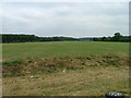
South end of Fairlands Valley Park.
This photograph was taken facing north into Fairlands Valley Park from the car park used for Stevenage Borough FC (see TL2422). This park is also used for travelling fairs and circuses.
Image: © Robin Hall
Taken: 21 Jul 2005
0.09 miles
2
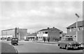
Stevenage New Town, 1956
View northward in Rockingham Way, by the Twin Foxes Inn: my new Morris Oxford featured on the right.
Image: © Ben Brooksbank
Taken: 28 Apr 1956
0.15 miles
3
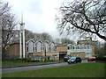
The Church of Jesus Christ of Latter-Day Saints - Stevenage.
With such a long title there is little else to say. Typical of Stevenage's churches, this is modern.
Image: © Robin Hall
Taken: 17 Jan 2005
0.22 miles
4
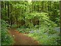
Monk's Wood, Stevenage
Bluebells everywhere!
Image: © Ray Stanton
Taken: 7 May 2006
0.23 miles
5
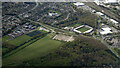
Stevenage from the air
Lamex Stadium, the home of Stevenage FC is prominent.
Image: © Thomas Nugent
Taken: 17 Apr 2024
0.23 miles
6
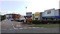
Monkswood Retail Park
McDonald's is here together with Mothercare, Comet, Topps Tiles and Blockbuster Video.
Image: © Mike W Hallett
Taken: 16 Oct 2009
0.24 miles