IMAGES TAKEN NEAR TO
Shephall View, STEVENAGE, SG1 1RP
Introduction
This page details the photographs taken nearby to Shephall View, SG1 1RP by members of the Geograph project.
The Geograph project started in 2005 with the aim of publishing, organising and preserving representative images for every square kilometre of Great Britain, Ireland and the Isle of Man.

There are currently over 7.5m images from over14,400 individuals and you can help contribute to the project by visiting https://www.geograph.org.uk
Image Map
Images are licensed for reuse under creativecommons.org/licenses/by-sa/2.0
Notes
- Clicking on the map will re-center to the selected point.
- The higher the marker number, the further away the image location is from the centre of the postcode.
Image Listing (18 Images Found)
Images are licensed for reuse under creativecommons.org/licenses/by-sa/2.0
Image
Details
Distance
4
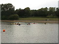
Learning to canoe in Fairlands Valley Park.
Image: © Jeff Tomlinson
Taken: 12 Jun 2005
0.13 miles
5
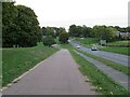
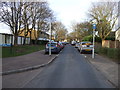
Cycle path, Stevenage
A cycle path, with a pedestrian path and a road alongside, in Stevenage.
Image: © Malc McDonald
Taken: 25 Sep 2022
0.15 miles
6
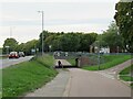
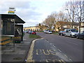
Pedestrian and cycle path, Stevenage
A pedestrian and cycle path alongside a busy road in Stevenage.
Image: © Malc McDonald
Taken: 25 Sep 2022
0.15 miles
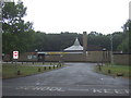
8
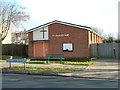
Salvation Army Church Hall
Located in Bedwell Crescent.
Image: © Robin Hall
Taken: 25 Jan 2006
0.17 miles
10
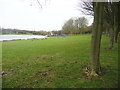
Fairlands Valley Park, near the car park
To the right there is a double line of trees. On the left is the Sailing Lake, and on the grass a flock of geese.
Image: © Humphrey Bolton
Taken: 29 Jan 2019
0.18 miles