IMAGES TAKEN NEAR TO
Meadow Way, STEVENAGE, SG1 1QD
Introduction
This page details the photographs taken nearby to Meadow Way, SG1 1QD by members of the Geograph project.
The Geograph project started in 2005 with the aim of publishing, organising and preserving representative images for every square kilometre of Great Britain, Ireland and the Isle of Man.

There are currently over 7.5m images from over14,400 individuals and you can help contribute to the project by visiting https://www.geograph.org.uk
Image Map
Images are licensed for reuse under creativecommons.org/licenses/by-sa/2.0
Notes
- Clicking on the map will re-center to the selected point.
- The higher the marker number, the further away the image location is from the centre of the postcode.
Image Listing (10 Images Found)
Images are licensed for reuse under creativecommons.org/licenses/by-sa/2.0
Image
Details
Distance
1
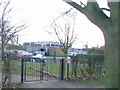
Bedwell JMI School.
Another of Stevenage's schools set in a cluster with others.
Image: © Robin Hall
Taken: 25 Jan 2006
0.07 miles
2
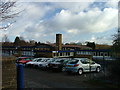
St Vincent De Paul Roman Catholic Primary School
Does what it says on the tin.
Image: © Robin Hall
Taken: 25 Jan 2006
0.11 miles

5

St Joseph's Church and Presbytery
A modern church set in its own grounds.
Image: © Robin Hall
Taken: 25 Jan 2006
0.16 miles
6
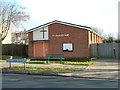
Salvation Army Church Hall
Located in Bedwell Crescent.
Image: © Robin Hall
Taken: 25 Jan 2006
0.17 miles
7
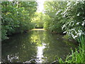
Stevenage: Fairlands Valley Park
The second lake going downstream viewed from the weir to the third lake.
Image: © Nigel Cox
Taken: 18 May 2006
0.19 miles
8
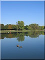
Sailing Lake at Fairlands Valley Park
This was taken on 5/10/2007 - a rare early autumn day when the lake was like a mirror
Image: © Jo Hennessey
Taken: 5 Oct 2007
0.20 miles
9
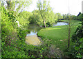
Stevenage: Fairlands Valley Park
The second lake, going downstream, of the four in the park, this is the reverse view from Image
Image: © Nigel Cox
Taken: 18 May 2006
0.21 miles
10
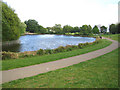
Stevenage: Fairlands Valley Park
The third of the four lakes going downstream. Fairlands was the name of the hamlet in the area before the post-war urban sprawl of Stevenage swallowed it up.
Image: © Nigel Cox
Taken: 18 May 2006
0.21 miles