IMAGES TAKEN NEAR TO
SE20 7BD
Introduction
This page details the photographs taken nearby to SE20 7BD by members of the Geograph project.
The Geograph project started in 2005 with the aim of publishing, organising and preserving representative images for every square kilometre of Great Britain, Ireland and the Isle of Man.

There are currently over 7.5m images from over14,400 individuals and you can help contribute to the project by visiting https://www.geograph.org.uk
Image Map
Images are licensed for reuse under creativecommons.org/licenses/by-sa/2.0
Notes
- Clicking on the map will re-center to the selected point.
- The higher the marker number, the further away the image location is from the centre of the postcode.
Image Listing (151 Images Found)
Images are licensed for reuse under creativecommons.org/licenses/by-sa/2.0
Image
Details
Distance
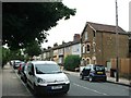
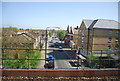
1
Parish Lane at the junction of Thesiger Road
Image: © David Howard
Taken: 18 Oct 2015
0.02 miles
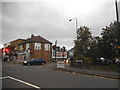
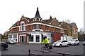
2
Penge: Church, built 1900
This building appears to be a fully-functioning church, but of what religion is not clear. Probably Christian Scientist.
Image: © Dr Neil Clifton
Taken: 31 Aug 2012
0.03 miles
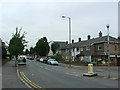
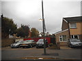
3
Parish Lane - Green Lane Junction
The late Victorian building is now used as a "right on" evangelical church
Image: © Glyn Baker
Taken: 27 Mar 2019
0.03 miles
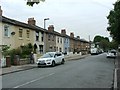
5
House and garages on Parish Lane, Penge
Image: © David Howard
Taken: 18 Oct 2015
0.05 miles
7
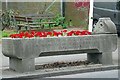
Benjamin's Trough
A Victorian horse trough in Penge.
Image: © Glyn Baker
Taken: 27 Mar 2019
0.05 miles
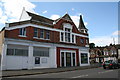
8
"Actually Mate I work in Advertising!"
I was going to title this photograph "Bill Sticker".
Image: © Glyn Baker
Taken: 27 Mar 2019
0.07 miles