IMAGES TAKEN NEAR TO
Borough High Street, LONDON, SE1 9SE
Introduction
This page details the photographs taken nearby to Borough High Street, SE1 9SE by members of the Geograph project.
The Geograph project started in 2005 with the aim of publishing, organising and preserving representative images for every square kilometre of Great Britain, Ireland and the Isle of Man.

There are currently over 7.5m images from over14,400 individuals and you can help contribute to the project by visiting https://www.geograph.org.uk
Image Map
Images are licensed for reuse under creativecommons.org/licenses/by-sa/2.0
Notes
- Clicking on the map will re-center to the selected point.
- The higher the marker number, the further away the image location is from the centre of the postcode.
Image Listing (3532 Images Found)
Images are licensed for reuse under creativecommons.org/licenses/by-sa/2.0
Image
Details
Distance
1
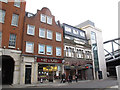
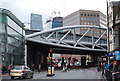
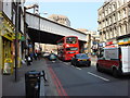
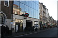
Pret and Tito's, London Bridge Street
Situated on London Bridge Street (effectively the station carriage drive), Pret (which was about to move round the corner - see Image) occupies an undated building with a Dutch style of architecture, and next door Tito's restaurant occupies a building dated 1872 with later additional storeys.
Image: © Stephen Craven
Taken: 21 Jan 2014
0.01 miles
2
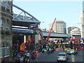
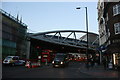
Bridge installation, Borough High Street
Borough High Street on 30th April 2011. The road was closed for the weekend, to allow a new bridge to be slid into position. The new bridge can be seen to the left. By the end of the weekend, it had been moved to its final position, over the road.
The bridge has been installed as part of the "Thameslink Programme", a major scheme to upgrade capacity of the "Thameslink" railway line which links South and North London. More information about the programme is available at Network Rail's website http://www.networkrail.co.uk/aspx/6345.aspx
Image: © Malc McDonald
Taken: 30 Apr 2011
0.01 miles
3
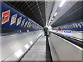
Escalator at London Bridge underground station
Image: © Oast House Archive
Taken: 15 Apr 2012
0.01 miles
5
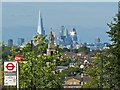
London skyline from the south
A telephoto shot taken from Image, the bus stop indicating the location.
In the middle distance is the tower of Image
About five and a half miles away, the Shard http://www.geograph.org.uk/photo/2912636 now obscures some buildings that were previously visible from this point http://www.geograph.org.uk/photo/1658415 .
Sunlight is reflected from the Gherkin http://www.geograph.org.uk/photo/1280849 .
Image: © Robin Drayton
Taken: 16 Sep 2012
0.01 miles
8
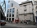
London Bridge Post Office and new building
The building on the right of the photo is currently the Crown Post Office. The building is listed grade 2 (list entry number 1378344) and was built in 1842-4 as a ward block of the original St Thomas's Hospital, now post office.
The office building on the left is new - completed in 2012, replacing a row of shops Image Behind it is the glass facade of "The Place".
Image: © Stephen Craven
Taken: 17 Oct 2013
0.01 miles