IMAGES TAKEN NEAR TO
Stamford Street, LONDON, SE1 9NN
Introduction
This page details the photographs taken nearby to Stamford Street, SE1 9NN by members of the Geograph project.
The Geograph project started in 2005 with the aim of publishing, organising and preserving representative images for every square kilometre of Great Britain, Ireland and the Isle of Man.

There are currently over 7.5m images from over14,400 individuals and you can help contribute to the project by visiting https://www.geograph.org.uk
Image Map
Images are licensed for reuse under creativecommons.org/licenses/by-sa/2.0
Notes
- Clicking on the map will re-center to the selected point.
- The higher the marker number, the further away the image location is from the centre of the postcode.
Image Listing (1897 Images Found)
Images are licensed for reuse under creativecommons.org/licenses/by-sa/2.0
Image
Details
Distance
1
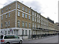
95 - 123 (odds) Stamford Street, SE1
This excludes the near corner, the rest of the row is grade II listed, mid 19th century.
Image: © Robin Webster
Taken: 14 Mar 2009
0.01 miles
2
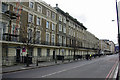
Stamford Street, SE1
The south side viewed from nearly opposite the London Nautical School.
Image: © Robin Webster
Taken: 14 Mar 2009
0.02 miles
3

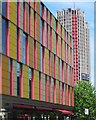
Coin Street Neighbourhood Centre
On the north side of Stamford Street, SE1. The tall building on the right is King's Reach Tower.
Image: © Robin Stott
Taken: 13 May 2012
0.02 miles
5
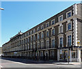
95-123 Stamford Street
A long terrace of 1829, its Georgian reticence trampled all over by Edwardians who added the heavy window details and pilastered centrepiece. A similar terrace follows beyond. Grade II listed.
Image: © Stephen Richards
Taken: 20 Apr 2013
0.03 miles
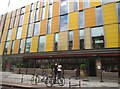
6
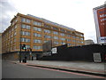
Coin Street Neighbourhood Centre
The Coin Street neighbourhood centre on Stamford Street provides community facilities and services to families in the area. Designed by Haworth Tompkins Architects.
Image: © Patrick Mackie
Taken: 30 Jun 2013
0.03 miles
7
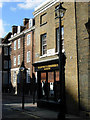
Roupell Street, Waterloo
A piece of old London at the corner of Roupell Street and Cornwall Road. Roupell Street is part of a conservation area.
Image: © Stephen McKay
Taken: 6 Mar 2007
0.04 miles
8
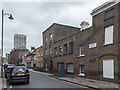
Cornwall Road, London SE1
Some old buildings have escaped destruction.
Image: © Christine Matthews
Taken: 8 Mar 2015
0.04 miles
10
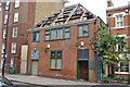
Former Cornwall Club, Cornwall Road, SE1
Derelict, but most of the facade has an inner skin of breeze blocks. The sign has what looks like 'N.C. Lambeth Scouts [illegible but not Guides] Cornwall Club'. It was later demolished and flats filled the gap.
Image: © Robin Webster
Taken: 14 Mar 2009
0.04 miles