IMAGES TAKEN NEAR TO
Sumner Street, LONDON, SE1 9JY
Introduction
This page details the photographs taken nearby to Sumner Street, SE1 9JY by members of the Geograph project.
The Geograph project started in 2005 with the aim of publishing, organising and preserving representative images for every square kilometre of Great Britain, Ireland and the Isle of Man.

There are currently over 7.5m images from over14,400 individuals and you can help contribute to the project by visiting https://www.geograph.org.uk
Image Map
Images are licensed for reuse under creativecommons.org/licenses/by-sa/2.0
Notes
- Clicking on the map will re-center to the selected point.
- The higher the marker number, the further away the image location is from the centre of the postcode.
Image Listing (2032 Images Found)
Images are licensed for reuse under creativecommons.org/licenses/by-sa/2.0
Image
Details
Distance
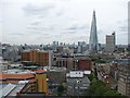
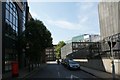
3
East end of Sumner Street
This section of the street is coincidentally aligned towards the Shard.
Image: © Stephen Craven
Taken: 14 Mar 2014
0.02 miles
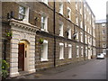
4
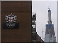
Corporation of London Housing
London coat of arms at the Peabody Estate off Southwark Street. Rising in the background is "The Shard", a high rise development under construction.
www.peabody.org.uk
Image: © Colin Smith
Taken: 18 Mar 2011
0.03 miles
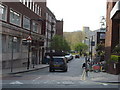
5

Looking westwards in Park Street
Taken on the Pepys Walk, a circular walk around the City of London and the South bank starting and finishing at St Paul's Cathedral.
Image: © Basher Eyre
Taken: 17 Apr 2009
0.03 miles
6
Peabody Estate, Southwark
One of several estates in London to give better quality and cheap housing to the poor. They get their name from the American philanthropist, George Peabody who set up the Peabody Trust.
www.peabody.org.uk
Image: © Colin Smith
Taken: 18 Mar 2011
0.04 miles
7
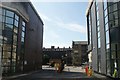
View of an access road between 133 and 135 Park Street
Looking south-southeast.
Image: © Robert Lamb
Taken: 26 Aug 2017
0.04 miles
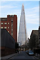
8
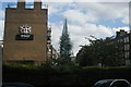
View of the Shard covered by a tree on Great Guildford Street
Looking south-southeast.
Image: © Robert Lamb
Taken: 26 Sep 2015
0.04 miles
9
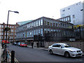
Site of St Peter's Church
St Peter's Church, Southwark (Anglican) stood on this site for a hundred years from 1839 to 1940 when it was destroyed by bombing. The only remaining artefact from the building is one of the bells which was taken to the Cathedral in 1952 where it is hung for chiming and known as the Peter bell.
The site is now occupied by a building which local sources say was once the National Grid control centre, but now used by various companies. As of 2014 a planning application was in progress for a 23-storey residential tower on the site.
Image: © Stephen Craven
Taken: 14 Mar 2014
0.04 miles
10
View down Emerson Street from Park Street
Looking south.
Image: © Robert Lamb
Taken: 26 Aug 2017
0.04 miles