1
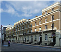
Anchor Terrace, Southwark Bridge Road
Built 1834 for the Anchor Brewery. The ends and centre project and have an extra storey. Grade II listed.
Still flats, but the brewery has long since departed.
Image: © Stephen Richards
Taken: 6 May 2013
0.01 miles
2
View of the Motability Head Office from Park Street
Looking south-southeast.
Image: © Robert Lamb
Taken: 26 Aug 2017
0.01 miles
3
Junction of Park Street and New Globe Walk
Taken on the Pepys Walk, a circular walk around the City of London and the South bank starting and finishing at St Paul's Cathedral.
Image: © Basher Eyre
Taken: 17 Apr 2009
0.02 miles
4
View From St.Paul's Cathedral (11)
Taken from the Golden Gallery.
http://www.stpauls.co.uk/Cathedral-History/Explore-the-Dome
Looking across the River Thames. The Globe can be seen on the river bank, just to the right of centre. On the skyline, the television transmitters at Crystal Palace can be seen; BBC on the left, ITV on the right.
Image: © Peter Trimming
Taken: 14 Jul 2009
0.02 miles
5
Southwark Bridge Road
The road leading up to the bridge over the Thames from Southwark. The further building on the left is Rose Court, home of the Health and Safety Executive.
Image: © Derek Harper
Taken: 16 Nov 2007
0.02 miles
6
Mid section of Park Street
Taken on the Pepys Walk, a circular walk around the City of London and the South bank starting and finishing at St Paul's Cathedral.
Image: © Basher Eyre
Taken: 17 Apr 2009
0.02 miles
7
Thames, FT building and Southwark Bridge
Looking across the Thames from the riverside walkway between Cousin Lane and Queen Street Place.
Image: © Derek Harper
Taken: 19 May 2006
0.03 miles
8
View from Tate Modern, London
Eastwards view from the viewing area at the Tate Modern.
Image: © Christine Matthews
Taken: 16 May 2017
0.03 miles
9
View of an access road between 133 and 135 Park Street
Looking south-southeast.
Image: © Robert Lamb
Taken: 26 Aug 2017
0.03 miles
10
East end of Sumner Street
This section of the street is coincidentally aligned towards the Shard.
Image: © Stephen Craven
Taken: 14 Mar 2014
0.03 miles


