IMAGES TAKEN NEAR TO
St. Thomas Street, LONDON, SE1 9BF
Introduction
This page details the photographs taken nearby to St. Thomas Street, SE1 9BF by members of the Geograph project.
The Geograph project started in 2005 with the aim of publishing, organising and preserving representative images for every square kilometre of Great Britain, Ireland and the Isle of Man.

There are currently over 7.5m images from over14,400 individuals and you can help contribute to the project by visiting https://www.geograph.org.uk
Image Map
Images are licensed for reuse under creativecommons.org/licenses/by-sa/2.0
Notes
- Clicking on the map will re-center to the selected point.
- The higher the marker number, the further away the image location is from the centre of the postcode.
Image Listing (3346 Images Found)
Images are licensed for reuse under creativecommons.org/licenses/by-sa/2.0
Image
Details
Distance
3
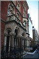
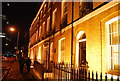
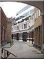
2-16 St Thomas Street
An early C19th group, most of the houses of two bays and three storeys plus basements and attics. A continuous cornice and platband runs for most of its length - the last two do not appear to be of the same build. Grade II listed.
Nearest is the Bunch of Grapes pub, also early C19th though originally a house. Grade II listed.
Looming behind is Guy's Tower (1963-75, by Watkins Gray & Partners).
Image: © Stephen Richards
Taken: 6 May 2013
0.01 miles
5
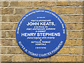
Plaque to Keats and Stephens
John Keats is best known as a poet but here he is commemorated along with lesser know Henry Stephens as an apothecary student at Guy's hospital c.1815. The plaque is on a building on the south side of St Thomas Street Image
Image: © Stephen Craven
Taken: 27 Feb 2014
0.01 miles
6
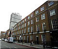
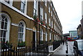
St Thomas Street, south side
A terrace of early 19th century town houses, listed grade 2 (list entry number 1385871). There is a blue plaque in the centre of the photo Image
Image: © Stephen Craven
Taken: 27 Feb 2014
0.01 miles
7
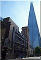
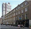
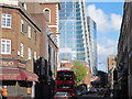
St Thomas Street, London, SE1
The Shard tower seen from the Borough High Street end of St Thomas Street. The church-like building with the square tower is the former church (chapel) of St Thomas' Hospital (prior to that hospital's move to Lambeth). When the earlier version of St Thomas' Hospital was transferred to its present site in 1822, its operating theatre (a room) in the garret of this church was boarded up and lay undiscovered until 1956. Although it may seem strange that the hospital's operating facility was established in a church tower, access to this tower-top level operating theatre was from wards that existed on the first floor of the hospital's south wing and access was via a doorway in the north wall of the church tower's, at the same level.
Image: © David Hallam-Jones
Taken: 5 May 2014
0.01 miles
8
Terraced houses, St Thomas St
Grade II listed. http://www.britishlistedbuildings.co.uk/en-471290-numbers-4-8-and-12-16-and-attached-raili
Image: © N Chadwick
Taken: 12 Feb 2012
0.01 miles
10
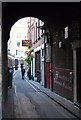
Kings Head Yard
This is a former coaching Inn off Borough High St
Image: © N Chadwick
Taken: 7 Dec 2008
0.02 miles