IMAGES TAKEN NEAR TO
Glade Path, LONDON, SE1 8EG
Introduction
This page details the photographs taken nearby to Glade Path, SE1 8EG by members of the Geograph project.
The Geograph project started in 2005 with the aim of publishing, organising and preserving representative images for every square kilometre of Great Britain, Ireland and the Isle of Man.

There are currently over 7.5m images from over14,400 individuals and you can help contribute to the project by visiting https://www.geograph.org.uk
Image Map
Images are licensed for reuse under creativecommons.org/licenses/by-sa/2.0
Notes
- Clicking on the map will re-center to the selected point.
- The higher the marker number, the further away the image location is from the centre of the postcode.
Image Listing (296 Images Found)
Images are licensed for reuse under creativecommons.org/licenses/by-sa/2.0
Image
Details
Distance
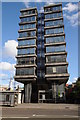
1
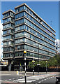
Hill House, Blackfriars Road
A substantial 1960s office block. The lettering looks original. The end wall is faced in subtly-varied coloured panels.
For at least the last two years it has lain empty and boarded up, and one imagines that eventually it will be pulled down. This stretch of Blackfriars Road is strange - bitty, incoherent and oddly quiet given its proximity to both Elephant and Castle, and the South Bank.
Image: © Stephen Richards
Taken: 14 Aug 2011
0.03 miles
2
Prefabs on Milcote Street, SE1
There can't be many of these left now. They were built as emergency accommodation after World War 2 bombing destroyed a lot of the area's housing stock. Never intended to last more than a few years, they have proved more durable and more popular than the concrete tower blocks that followed them. A real accidental success story. One thing's for sure -- come back here in 10 year's time and you are unlikely still to see these.
Image: © Danny P Robinson
Taken: 4 May 2007
0.04 miles
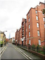
3
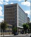
Erlang House, Blackfriars Road
Office block built c1960, metal-framed windows set between thin concrete bands. In front of the recessed entrance stand prominently tapering pilotis.
At the time much of the space was available to rent by artists as studios, an initiative of a charity, Artists Studio Company. In a previous life, and in common with countless other office blocks, it was occupied by British Telecom.
Image: © Stephen Richards
Taken: 14 Aug 2011
0.04 miles
4
Erlang House, Blackfriars Road
Office block on Blackfriars Road. The Shard can be seen in the distance to the left.
Image: © Philip Halling
Taken: 1 Nov 2014
0.04 miles
5
King James Street, Southwark
King James Street in inner south east London. The Shard is visible in the background.
Image: © Malc McDonald
Taken: 26 Oct 2020
0.04 miles
6
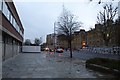
Blackfriars Road
Looking along Blackfriars Road just south of the Webber Street junction.
Image: © DS Pugh
Taken: 11 Dec 2015
0.05 miles
7
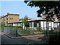
Bankside community garden, King James Street
The garden is run by the Bankside Open Spaces Trust http://www.bost.org.uk/
Image: © Stephen Craven
Taken: 12 Aug 2008
0.05 miles
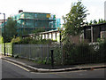
8
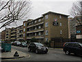
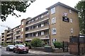
Markstone House, Lancaster Street
A four storey block of flats, one of many post-war Corporation of London social housing developments in Southwark.
Image: © Stephen Craven
Taken: 8 Mar 2015
0.05 miles
9
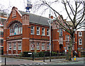
Passmore Edwards library, Borough Road
By A.B. Jackson in 1898. Arts and Crafts style, although some of the carved terracotta detail is Art Nouveau-ish. Grade II listed.
Image: © Stephen Richards
Taken: 2 Apr 2011
0.05 miles