IMAGES TAKEN NEAR TO
Isabella Street, LONDON, SE1 8DD
Introduction
This page details the photographs taken nearby to Isabella Street, SE1 8DD by members of the Geograph project.
The Geograph project started in 2005 with the aim of publishing, organising and preserving representative images for every square kilometre of Great Britain, Ireland and the Isle of Man.

There are currently over 7.5m images from over14,400 individuals and you can help contribute to the project by visiting https://www.geograph.org.uk
Image Map
Images are licensed for reuse under creativecommons.org/licenses/by-sa/2.0
Notes
- Clicking on the map will re-center to the selected point.
- The higher the marker number, the further away the image location is from the centre of the postcode.
Image Listing (870 Images Found)
Images are licensed for reuse under creativecommons.org/licenses/by-sa/2.0
Image
Details
Distance
1
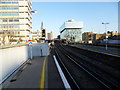
Looking down the line from Waterloo East station
The station was opened by the South Eastern Railway as Waterloo Junction in January 1869. The Southern Railway renamed it Waterloo Eastern in 1935 and it took its present name in May 1977. There was once a rail connection to the main Waterloo station but this saw little service and was closed at the beginning of the 20th century. This view looks down the line from Platform A towards London Bridge station, with the nearly completed Shard at London Bridge on the left in the distance. The platforms at Waterloo East are given the letters A to D to avoid confusion with the numbered platforms at the main Waterloo station.
Image: © Marathon
Taken: 1 Feb 2012
0.01 miles
2
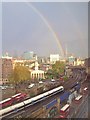
Is there a crock of gold at the Shard?
Taken from the window of an office
Image: © Deborah Wright
Taken: 10 Nov 2014
0.01 miles
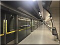
3
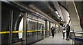
Jubilee Line, Southwark Underground Station
Image: © N Chadwick
Taken: 24 May 2014
0.02 miles
4
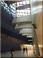
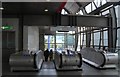
Lightwell at Southwark tube station
From the main concourse one goes down an escalator and is then surprised by the daylight coming down from this large skylight. Straight on leads to the stairs up to Waterloo East station (National Rail) and further escalators to the right lead down to the Jubilee Line.
Image: © Stephen Craven
Taken: 7 Dec 2014
0.02 miles
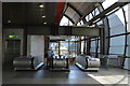
9
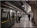
Southwark tube station, Westbound platform
Southwark tube station was opened on 20 November 1999 as part of the Jubilee Line Extension. The station has a direct connection with the mainline at Waterloo East. Confusingly, the station is some way to the west of historic Southwark, which is served by Borough tube station.
Southwark station was designed by Richard MacCormac of MacCormac Jamieson Prichard. The station is built on a cramped site, with the platforms lying underneath the Victorian railway viaduct carrying trains between Waterloo East and London Bridge railway station.
Image: © Oxyman
Taken: 17 Jun 2008
0.02 miles
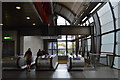
10
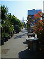
Isabella Street
This view is east. The end of the street at Joan Street can be made out ahead. The Shard is in the background.
Image: © Shazz
Taken: 7 May 2013
0.02 miles