IMAGES TAKEN NEAR TO
Frazier Street, LONDON, SE1 7RD
Introduction
This page details the photographs taken nearby to Frazier Street, SE1 7RD by members of the Geograph project.
The Geograph project started in 2005 with the aim of publishing, organising and preserving representative images for every square kilometre of Great Britain, Ireland and the Isle of Man.

There are currently over 7.5m images from over14,400 individuals and you can help contribute to the project by visiting https://www.geograph.org.uk
Image Map
Images are licensed for reuse under creativecommons.org/licenses/by-sa/2.0
Notes
- Clicking on the map will re-center to the selected point.
- The higher the marker number, the further away the image location is from the centre of the postcode.
Image Listing (1023 Images Found)
Images are licensed for reuse under creativecommons.org/licenses/by-sa/2.0
Image
Details
Distance
1
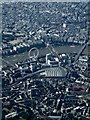
Central London from the air
Waterloo railway station and the London Eye dominate the foreground, with the River Thames, Charing Cross railway station and Trafalgar Square also visible.
Image: © Thomas Nugent
Taken: 30 Jul 2014
0.02 miles
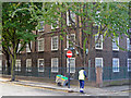
3
Looking across Baylis Road towards Frazer Street (southern section)
Image: © Basher Eyre
Taken: 10 Jul 2010
0.04 miles
4
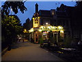
The Duke of Sussex, Coral Street
A pub trying to link with traditional by displaying the former brewery name. Truman Hanbury Buxton & Co was active for over 200 years until being swallowed up and destroyed by Watney's in the dark days of the 1970s.
Image: © Bill Boaden
Taken: 2 Aug 2011
0.04 miles
5
Sweeping Pearman Street, Waterloo
A street sweeper energetically deals with leaves in the gutter of Pearman Street at the junction with Coral Street. The block behind is Greet House, part of the Tanswell Estate.
Image: © Stephen McKay
Taken: 29 Oct 2007
0.04 miles
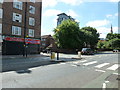
6
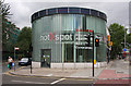
Regenerate IT Hot Spot
Offices of a company which is a wifi e-inclusion specialist, with an internet cafe, located at the junction of Pearman Street and Waterloo Road, with Coral Street behind. Fuller details about the company can be found on their website which is displayed on the building.
Image: © Martin Addison
Taken: 2 Aug 2008
0.04 miles
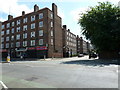
7
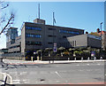
London Ambulance Headquarters, Waterloo Road
A severe grey-mosaic-clad block by the Greater London Council's Architect's Department, c1970. It stretches a long way behind down Morley Street.
Image: © Stephen Richards
Taken: 20 Apr 2013
0.04 miles

9
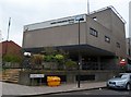
London Ambulance HQ, Pearman Street SE1
Taken from the junction with Waterloo Road
Image: © Robin Sones
Taken: 17 Feb 2012
0.05 miles
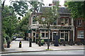
10
London: the Duke of Sussex, Baylis Road
A traditional pub on Baylis Road, close to Waterloo Station. It stands on what was previously the main carriageway of Baylis Road - but the gardens alongside now encroach on the former course of the street and the 'stub' of roadway now forms a beer garden of picnic tables.
The Truman Hanbury Buxton fascia of the pub refers to a brewery that dates back to 1666 but closed in 1989, although it was revived in 2010.
Image: © Chris Downer
Taken: 11 Sep 2014
0.05 miles