IMAGES TAKEN NEAR TO
King Edward Walk, LONDON, SE1 7PR
Introduction
This page details the photographs taken nearby to King Edward Walk, SE1 7PR by members of the Geograph project.
The Geograph project started in 2005 with the aim of publishing, organising and preserving representative images for every square kilometre of Great Britain, Ireland and the Isle of Man.

There are currently over 7.5m images from over14,400 individuals and you can help contribute to the project by visiting https://www.geograph.org.uk
Image Map
Images are licensed for reuse under creativecommons.org/licenses/by-sa/2.0
Notes
- Clicking on the map will re-center to the selected point.
- The higher the marker number, the further away the image location is from the centre of the postcode.
Image Listing (509 Images Found)
Images are licensed for reuse under creativecommons.org/licenses/by-sa/2.0
Image
Details
Distance
3
Zebra crossing nearing the Imperial War Museum
Taken in Lambeth Road.
Image: © Basher Eyre
Taken: 10 Jul 2010
0.04 miles
5
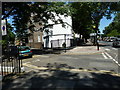
Junction of King Edward Walk and Lambeth Road
Image: © Basher Eyre
Taken: 10 Jul 2010
0.04 miles
6
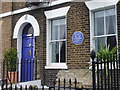
William Bligh Lived Here
Blue plaque and history on the Lambeth Road, opposite the Imperial War Museum.
Image: © Colin Smith
Taken: 18 Mar 2011
0.04 miles
7
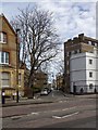
King Edward Walk
Looking NNE across Lambeth Road up King Edward Walk.
Image: © David P Howard
Taken: 14 Apr 2013
0.04 miles
9
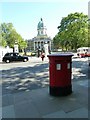
Postbox opposite the Imperial War Museum
Image: © Basher Eyre
Taken: 10 Jul 2010
0.05 miles
10
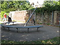
Sundial at Lambeth
This Sundial, in Geraldine Mary Harmsworth Park, was constructed in... wait for it... the shadow of a huge tree.
Image: © Derek Voller
Taken: 25 Sep 2009
0.05 miles