IMAGES TAKEN NEAR TO
Albert Embankment, LONDON, SE1 7HG
Introduction
This page details the photographs taken nearby to Albert Embankment, SE1 7HG by members of the Geograph project.
The Geograph project started in 2005 with the aim of publishing, organising and preserving representative images for every square kilometre of Great Britain, Ireland and the Isle of Man.

There are currently over 7.5m images from over14,400 individuals and you can help contribute to the project by visiting https://www.geograph.org.uk
Image Map
Images are licensed for reuse under creativecommons.org/licenses/by-sa/2.0
Notes
- Clicking on the map will re-center to the selected point.
- The higher the marker number, the further away the image location is from the centre of the postcode.
Image Listing (686 Images Found)
Images are licensed for reuse under creativecommons.org/licenses/by-sa/2.0
Image
Details
Distance
1
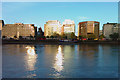
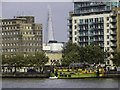
Albert Embankment
View from Millbank looking across the Thames to the North end of Albert Embankment.
Image: © Peter McDermott
Taken: 20 May 2008
0.01 miles
2
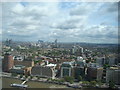
General view over London, viewed from Altitude 360
Taken whilst attending a London Photo Walk, this is a general view of London taken from the viewing gallery of Altitude 360 on the top floor of the Millbank Tower looking east-southeast.
Image: © Robert Lamb
Taken: 29 Aug 2010
0.01 miles
5
A glimpse of the Shard
A brief glimpse of the Shard between the London Fire Brigade building and an apartment block on Albert Embankment, as seen from Millbank.
Image: © Chris Denny
Taken: 23 Sep 2014
0.01 miles
6

Building on Corner of Lambeth High Street
This ornate building is on the corner of Lambeth High Street and Black Prince Road. It is difficult to imagine anything being built like this today -- the skilled labour that built this would simply be too expensive now.
It used to be a part of Doulton's Pottery -- this link tells you more http://myweb.tiscali.co.uk/speel/london/doulton2.htm
Image: © Danny P Robinson
Taken: 10 May 2006
0.01 miles
7

Lambeth: London Fire Brigade Headquarters, Albert Embankment, SE1
In 2007 the London Fire Brigade sold this Headquarters building to housing developers with a view to moving the HQ to a site in Union Street SE1, close to their Training Centre, in 2008. This eight storey building was purpose built for the London Fire Brigade between 1934 and 1937, at a cost of about £390,000 including the purchase of the land, and was officially opened on 21 July 1937 by King George VI and Queen Elizabeth. It has seven turn-outs onto Albert Embankment, protected by the traffic lights.
Image: © Nigel Cox
Taken: 28 May 2008
0.01 miles
8
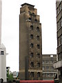
Lambeth: London Fire Brigade Headquarters drill tower
Most fire stations have drill towers and Image was no exception. This is the 100 feet high Grade II listed tower in the back yard of the HQ building. It was built in 1937 at the same time as the main building which had balconies at the rear for up to 800 people to view training routines including the use of the tower.
Image: © Nigel Cox
Taken: 28 May 2008
0.01 miles
9
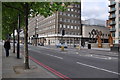
London : Lambeth - Albert Embankment A3036
A road along the Albert Embankment between Westminster Bridge and Vauxhall Bridge.
Image: © Lewis Clarke
Taken: 13 May 2011
0.01 miles
10
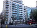
White Hart Dock, Lambeth, London
White Hart Dock is located between Lambeth and Vauxhall bridges at the junction of Albert Embankment and Black Prince Road. The Dock is on the land side of the Embankment, and was believed to have been used by the nearby Doulton’s factory until 1956 when they relocated the Staffordshire Potteries area.
Image: © PAUL FARMER
Taken: 16 Oct 2011
0.01 miles