IMAGES TAKEN NEAR TO
Falmouth Road, LONDON, SE1 6QP
Introduction
This page details the photographs taken nearby to Falmouth Road, SE1 6QP by members of the Geograph project.
The Geograph project started in 2005 with the aim of publishing, organising and preserving representative images for every square kilometre of Great Britain, Ireland and the Isle of Man.

There are currently over 7.5m images from over14,400 individuals and you can help contribute to the project by visiting https://www.geograph.org.uk
Image Map
Images are licensed for reuse under creativecommons.org/licenses/by-sa/2.0
Notes
- Clicking on the map will re-center to the selected point.
- The higher the marker number, the further away the image location is from the centre of the postcode.
Image Listing (435 Images Found)
Images are licensed for reuse under creativecommons.org/licenses/by-sa/2.0
Image
Details
Distance
1
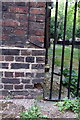
Benchmark on Martin House, Falmouth Road
Ordnance Survey cut mark benchmark described on the Bench Mark Database at http://www.bench-marks.org.uk/bm37843
Image: © Roger Templeman
Taken: 6 May 2011
0.02 miles
2
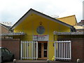
Rockingham Community Day Nursery
On Falmouth Road, SE1. There is obviously thought to be a need to secure the building well when unattended.
Image: © Danny P Robinson
Taken: 11 May 2007
0.03 miles
3
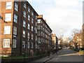
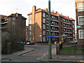
Aird House and Arroll House, Southwark
Looking along Rockingham Street, with Aird House (nearest) and Arroll House, two of several five-storey blocks of flats on the Rockingham estate. The Shard at London Bridge can be sheen in the distance, under construction.
Image: © Stephen Craven
Taken: 3 Mar 2011
0.04 miles
4
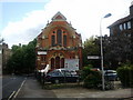
Brotherhood of the Cross and the Star, corner of Falmouth Road and County Street
Image: © Rob Purvis
Taken: 6 Jul 2011
0.06 miles
5
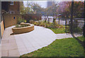
Community garden at St Matthew's
Urban landscaping outside the church in Meadow Row Image
Image: © Stephen Craven
Taken: 26 Apr 2005
0.06 miles
6
Banks House, Rockingham Street
One of several five-storey blocks of flats on the Rockingham estate.
Note the blue sign which marks part of a cycle route avoiding the notorious Elephant & Castle junction.
Image: © Stephen Craven
Taken: 3 Mar 2011
0.07 miles
7
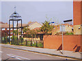
St Matthew at the Elephant
The name of this modern 'community' style church is officially "Southwark, Holy Trinity with St Matthew" but given its proximity to the "Elephant and Castle" shopping centre it has an unusual informal name. It was built in 1994 and the architect was Professor Hans Haenlein.
Image: © Stephen Craven
Taken: 26 Apr 2005
0.07 miles
8
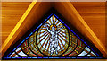
St Matthew at the Elephant, Meadow Row, London SE1 - Window
Image: © John Salmon
Taken: 16 Oct 2010
0.07 miles
9
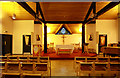
St Matthew at the Elephant, Meadow Row, London SE1 - East end
Image: © John Salmon
Taken: 16 Oct 2010
0.07 miles
10
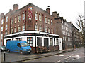
The Royal Standard, Harper Road
A pub on the corner of Harper Road and Falmouth Road.
Image: © Stephen Craven
Taken: 20 Mar 2010
0.08 miles