1
The Duke of Clarence, London Road SE1
Image: © Robin Sones
Taken: 8 Aug 2011
0.00 miles
2
The Duke of Clarence
Traditional ales are now a thing of the past at this former pub on St George's Circus, Southwark.
Image: © Colin Smith
Taken: 18 Mar 2011
0.01 miles
3
London Road Depot
The outside of the London Underground depot for the Bakerloo line.
Image: © Stephen Craven
Taken: 21 Aug 2008
0.01 miles
4
A wet day in the Lambeth Road, SE1
At the junction with London Road; two takeaways in modern buildings, with the wall of an older structure beyond
Image: © David Smith
Taken: 14 May 2015
0.01 miles
5
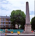
Obelisk, St George's Circus SE1
Taken from Borough Road looking across to Westminster Bridge Road
Image: © Robin Sones
Taken: 8 Aug 2011
0.01 miles
6
Memorial where Westminster Bridge Road meets London Road
Image: © Rob Purvis
Taken: 6 Jul 2011
0.02 miles
7
Obelisk on St George's Circus
This obelisk stands on St George's Circus at the centre of the road junction. It was designed by Robert Mylne. On the base of the obelisk is the inscription Erected in XI year of the reign of King George MDCCLXXI,
Image: © Philip Halling
Taken: 1 Nov 2014
0.02 miles
8
Obelisk in St George's Circus
The obelisk dates from the 18th century (1771); this side shows that it is one mile from Palace Yard. The plastic barriers and fencing date from the 21st century
Image: © David Smith
Taken: 14 May 2015
0.02 miles
9
St George's Circus, Southwark
St George's Circus is a road junction in Southwark, London, England. At its centre, which is now a traffic roundabout, is a historic obelisk, designed by Robert Mylne (1733–1811), in his role as surveyor and architect of Blackfriars Bridge. It was built in 1771 to mark the completion of the new roads through St George's Fields in the parish of Southwark St George the Martyr during the tenure of Brass Crosby as Lord Mayor of the City of London. In 1905, the obelisk was relocated to Geraldine Mary Harmsworth Park, in front of the Imperial War Museum close by, to accommodate a new clock tower. The clocktower was demolished as a "nuisance to traffic" in the 1930s, but the obelisk did not return to its original location until the late 1990s. At the base of the obelisk is the inscription Erected in XI year of the reign of King George MDCCLXXI, with the inscriptions on the other three sides reflecting the obelisk's one-mile distance from Palace Yard, London Bridge and Fleet Street. Behind the obelisk can be seen ‘The Duke of Clarence’ which is now part of the University of the South Bank.
Image: © Len Williams
Taken: 17 Jun 2015
0.02 miles
10
St George's Circus
From Blackfriars Road.
Image: © Robin Sones
Taken: 3 Feb 2020
0.02 miles


