IMAGES TAKEN NEAR TO
Prioress Street, LONDON, SE1 4UZ
Introduction
This page details the photographs taken nearby to Prioress Street, SE1 4UZ by members of the Geograph project.
The Geograph project started in 2005 with the aim of publishing, organising and preserving representative images for every square kilometre of Great Britain, Ireland and the Isle of Man.

There are currently over 7.5m images from over14,400 individuals and you can help contribute to the project by visiting https://www.geograph.org.uk
Image Map
Images are licensed for reuse under creativecommons.org/licenses/by-sa/2.0
Notes
- Clicking on the map will re-center to the selected point.
- The higher the marker number, the further away the image location is from the centre of the postcode.
Image Listing (217 Images Found)
Images are licensed for reuse under creativecommons.org/licenses/by-sa/2.0
Image
Details
Distance
1
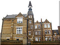
Former Weston Street School on Hunter Close (2)
A view of this converted school building from Prioress Street.
See also Image
Image: © Stephen Craven
Taken: 20 Mar 2010
0.01 miles
2
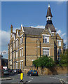
Tabard Centre, Hunter Close
Former Board School built in 1873-74, the tone leavened by a jolly bell-tower. Grade II listed.
I think it's now flats.
Image: © Stephen Richards
Taken: 6 May 2013
0.01 miles
3
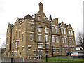
Former school on Hunter Close (1)
From the inscriptions over the doorways (such as "infants") this is clearly a former primary school, which has now been converted into apartments, but I could not find any reference online to its former name. See also Image
Image: © Stephen Craven
Taken: 20 Mar 2010
0.01 miles
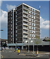
4
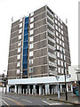
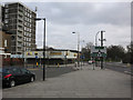
Tower block on Prioress Street
This is the only housing block of any significant height on Prioress Street (one of several in the area named after characters in the Canterbury Tales). I have not yet identified its name.
Image: © Stephen Craven
Taken: 20 Mar 2010
0.02 miles
5
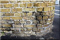
Benchmark on wall of Hunter Close at junction with Prioress Street
Ordnance Survey cut mark benchmark described on the Bench Mark Database at http://www.bench-marks.org.uk/bm37854
Image: © Roger Templeman
Taken: 6 May 2011
0.02 miles
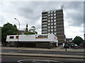
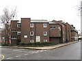
6
Peveril House, Rephidim Street
A 1960s LCC block, completed in 1965, with accompanying car park and 'amenity deck'.
Image: © Stephen Richards
Taken: 6 May 2013
0.02 miles
7
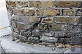
Benchmark on the wall of Potier Street at junction with Prioress Street
Ordnance Survey cut mark benchmark described on the Bench Mark Database at http://www.bench-marks.org.uk/bm37855
Image: © Roger Templeman
Taken: 6 May 2011
0.03 miles
10
Haddonhall Estate, Potier Street
This small estate on a triangular site appears to consist of more recent housing than that on surrounding streets.
Image: © Stephen Craven
Taken: 20 Mar 2010
0.04 miles