IMAGES TAKEN NEAR TO
Rothsay Street, LONDON, SE1 4UF
Introduction
This page details the photographs taken nearby to Rothsay Street, SE1 4UF by members of the Geograph project.
The Geograph project started in 2005 with the aim of publishing, organising and preserving representative images for every square kilometre of Great Britain, Ireland and the Isle of Man.

There are currently over 7.5m images from over14,400 individuals and you can help contribute to the project by visiting https://www.geograph.org.uk
Image Map
Images are licensed for reuse under creativecommons.org/licenses/by-sa/2.0
Notes
- Clicking on the map will re-center to the selected point.
- The higher the marker number, the further away the image location is from the centre of the postcode.
Image Listing (313 Images Found)
Images are licensed for reuse under creativecommons.org/licenses/by-sa/2.0
Image
Details
Distance
1
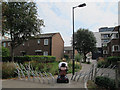
Unusual barrier
The lady on a mobility scooter was negotiating a barrier intended to keep out vehicles from this path leading from Law Street to Rothsay Street.
Image: © Stephen Craven
Taken: 23 Aug 2013
0.01 miles
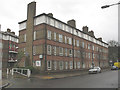
2
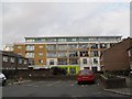
Rothsay Street
A small residents car park in the foreground, and behind is a building in the Wilds Rents redevelopment Image
Image: © Stephen Craven
Taken: 8 Mar 2015
0.02 miles
3
Thorn Ham House, Law Street
Note the bicycles on one of the balconies - a common sight in London nowadays.
Image: © Stephen Craven
Taken: 8 Mar 2015
0.03 miles
4
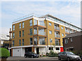
New building on Wilds Rents
Five years after the demolition of the previous industrial buildings on the site Image the new residential development was finally completed.
Image: © Stephen Craven
Taken: 23 Aug 2013
0.03 miles
5
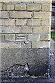
Benchmark on Chartham House, Weston Street
Ordnance Survey cut mark benchmark described on the Bench Mark Database at http://www.bench-marks.org.uk/bm37856
Image: © Roger Templeman
Taken: 6 May 2011
0.04 miles
6
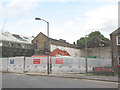
Demolition site, Wild's Rents
According to the Southwark Council planning application, the project granted permission in January 2008 consists of "Demolition of 3 Decima Studios, 17-19 Decima Street and Unit 5b, 20-28 Wild's Rents and erection of new 4 storey building plus basement comprising two (2) live work units; 1x3 bed with 63sqm office/studio space and 1x2 bed with 28sqm of office space, integral garage for 1 vehicle, cycle and waste storage facilities, plant room, carp pond, indoor lap pool, solar panel and greenhouse/hothouse." I quote this in full to illustrate the transition of Bermondsey in the early 2000's from light industry to expensive residential area.
Image shows the new development when complete.
Image: © Stephen Craven
Taken: 16 Jun 2008
0.04 miles
7
Weston Street
Looking along Weston Street from the junction with Law Street.
Image: © DS Pugh
Taken: 9 Dec 2016
0.05 miles
8
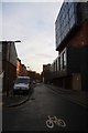
Along Rothsay Street
Rothsay Street has traffic measures to prevent vehicular through traffic.
Image: © DS Pugh
Taken: 9 Dec 2016
0.05 miles
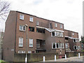
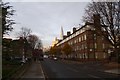
9
Weston Street, Elim Estate
One of the many low-rise housing blocks in this area of Southwark.
Image: © Stephen Craven
Taken: 20 Mar 2010
0.05 miles
10
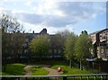
Outlook from The Jam Factory
View across pathways and residents' garden & seating area from flats in The Jam Factory (off Rothsay Street).
Image: © Clint Mann
Taken: 12 Apr 2011
0.07 miles