IMAGES TAKEN NEAR TO
Staple Street, LONDON, SE1 4LS
Introduction
This page details the photographs taken nearby to Staple Street, SE1 4LS by members of the Geograph project.
The Geograph project started in 2005 with the aim of publishing, organising and preserving representative images for every square kilometre of Great Britain, Ireland and the Isle of Man.

There are currently over 7.5m images from over14,400 individuals and you can help contribute to the project by visiting https://www.geograph.org.uk
Image Map
Images are licensed for reuse under creativecommons.org/licenses/by-sa/2.0
Notes
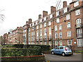
- Clicking on the map will re-center to the selected point.
- The higher the marker number, the further away the image location is from the centre of the postcode.
Image Listing (349 Images Found)
Images are licensed for reuse under creativecommons.org/licenses/by-sa/2.0
Image
Details
Distance
1
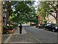
Staple Street, SE1
Through the Tabard Gardens Estate towards the Gardens.
Image: © Robin Webster
Taken: 19 Sep 2018
0.02 miles
2
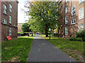
Path into Tabard Gardens
From Manciple Street in line with Staple Street.
Image: © Robin Webster
Taken: 19 Sep 2018
0.04 miles
3
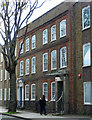
142-152 Long Lane
Sandwiched between modern additions is a handsome pair of early C18th houses. One has a very modern entrance, the other is original (Image]). Grade II* listed.
Image: © Stephen Richards
Taken: 27 May 2013
0.05 miles
4
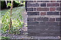
Benchmark on Aylesbury House, Long Lane
Ordnance Survey cut mark benchmark described on the Bench Mark Database at http://www.bench-marks.org.uk/bm37857
Image: © Roger Templeman
Taken: 6 May 2011
0.05 miles
5
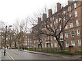
Manciple Street, Southwark
One of many streets in the area named after themes in Chaucer's "Canterbury Tales". According to Wikipedia, a manciple was in charge of the purchase and storage of food. It is an area of high-density residential housing, mostly belonging to Southwark Council. See also Image
Image: © Stephen Craven
Taken: 20 Mar 2010
0.06 miles
6
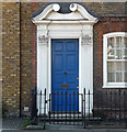
Detail of 142 Long Lane
Early C18th doorcase framed by fluted Corinthian pilasters and curly broken pediment.
Wider view: Image
Image: © Stephen Richards
Taken: 26 May 2013
0.06 miles
7
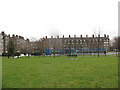
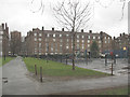
Tabard Gardens, looking south-east
The south-east end of the open space is given over to recreational facilities (children's play equipment and football courts). See also Image
Image: © Stephen Craven
Taken: 20 Mar 2010
0.06 miles
8
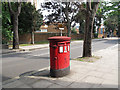
Post box on Long Lane
A double-slot post box.
Image: © Stephen Craven
Taken: 23 Aug 2013
0.06 miles
9
Housing on Manciple Street (backs)
The back of one of several similar blocks of housing on Manciple Street (itself one of many streets in the area named after themes in Chaucer's "Canterbury Tales").
Image: © Stephen Craven
Taken: 20 Mar 2010
0.06 miles
10
Path across Tabard Gardens
This path bisects the gardens to connect Manciple Street with Tabard Street. Children's playground to the right. See also Image / Image
Image: © Stephen Craven
Taken: 20 Mar 2010
0.06 miles