IMAGES TAKEN NEAR TO
Manciple Street, LONDON, SE1 4LR
Introduction
This page details the photographs taken nearby to Manciple Street, SE1 4LR by members of the Geograph project.
The Geograph project started in 2005 with the aim of publishing, organising and preserving representative images for every square kilometre of Great Britain, Ireland and the Isle of Man.

There are currently over 7.5m images from over14,400 individuals and you can help contribute to the project by visiting https://www.geograph.org.uk
Image Map
Images are licensed for reuse under creativecommons.org/licenses/by-sa/2.0
Notes
- Clicking on the map will re-center to the selected point.
- The higher the marker number, the further away the image location is from the centre of the postcode.
Image Listing (421 Images Found)
Images are licensed for reuse under creativecommons.org/licenses/by-sa/2.0
Image
Details
Distance
1
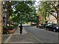
Staple Street, SE1
Through the Tabard Gardens Estate towards the Gardens.
Image: © Robin Webster
Taken: 19 Sep 2018
0.01 miles
2
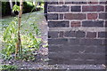
Benchmark on Aylesbury House, Long Lane
Ordnance Survey cut mark benchmark described on the Bench Mark Database at http://www.bench-marks.org.uk/bm37857
Image: © Roger Templeman
Taken: 6 May 2011
0.04 miles
3
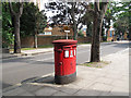
Post box on Long Lane
A double-slot post box.
Image: © Stephen Craven
Taken: 23 Aug 2013
0.04 miles
4
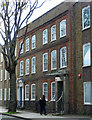
142-152 Long Lane
Sandwiched between modern additions is a handsome pair of early C18th houses. One has a very modern entrance, the other is original (Image]). Grade II* listed.
Image: © Stephen Richards
Taken: 27 May 2013
0.04 miles
5
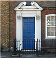
Detail of 142 Long Lane
Early C18th doorcase framed by fluted Corinthian pilasters and curly broken pediment.
Wider view: Image
Image: © Stephen Richards
Taken: 26 May 2013
0.05 miles
6
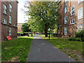
Path into Tabard Gardens
From Manciple Street in line with Staple Street.
Image: © Robin Webster
Taken: 19 Sep 2018
0.06 miles
7
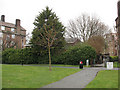
Site of St Stephen's church, Southwark
This gap between two housing blocks on the north side of Tabard Gardens was formerly occupied by St Stephen's church. Designed by S S Teulon and built in 1850, it closed in 1961 and was demolished in 1965. St George's Rectory now stands on the site (behind the tall hedge seen here).
Image: © Stephen Craven
Taken: 20 Mar 2010
0.06 miles
8
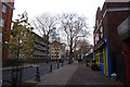
The Old School Yard
Looking along Long Lane past a pub called the Old School Yard.
Image: © DS Pugh
Taken: 9 Dec 2016
0.06 miles
9
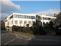
Gallery Court, Bermondsey
A small business unit on Pilgrimage Street.
Image: © Stephen Craven
Taken: 3 Mar 2011
0.07 miles
10
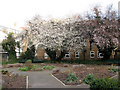
Hankey Place Gardens
Despite the name, the small garden is accessed from Pilgrimage Street (the next road to Hankey Place). The first of the spring blossom had just appeared at the start of March.
Image: © Stephen Craven
Taken: 3 Mar 2011
0.07 miles