IMAGES TAKEN NEAR TO
Tabard Street, LONDON, SE1 4LF
Introduction
This page details the photographs taken nearby to Tabard Street, SE1 4LF by members of the Geograph project.
The Geograph project started in 2005 with the aim of publishing, organising and preserving representative images for every square kilometre of Great Britain, Ireland and the Isle of Man.

There are currently over 7.5m images from over14,400 individuals and you can help contribute to the project by visiting https://www.geograph.org.uk
Image Map
Images are licensed for reuse under creativecommons.org/licenses/by-sa/2.0
Notes
- Clicking on the map will re-center to the selected point.
- The higher the marker number, the further away the image location is from the centre of the postcode.
Image Listing (575 Images Found)
Images are licensed for reuse under creativecommons.org/licenses/by-sa/2.0
Image
Details
Distance
1
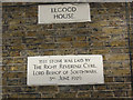
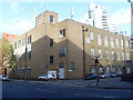
Dedication stone on Elgood House
For context see Image The Bishop referred to was Cyril Garbett http://en.wikipedia.org/wiki/Cyril_Garbett
Image: © Stephen Craven
Taken: 2 Mar 2010
0.00 miles
2
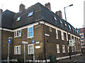
Elgood House, Nebraska Street, Southwark
Originally a Church Army housing association block but it now appears to be private housing and offices. Confusingly the Church Army now appears to use the same name for a hostel in London NW1. See Image and Image for building details.
Image: © Stephen Craven
Taken: 2 Mar 2010
0.00 miles
3
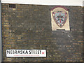
Church Army plaque on Elgood House
For context see Image
Image: © Stephen Craven
Taken: 2 Mar 2010
0.00 miles
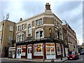
5
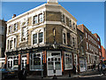
The Royal Oak, Tabard Street, Southwark
This is a daytime view of a well-known pub. Contrast the night-time view in Image which also gives more description.
Image: © Stephen Craven
Taken: 2 Mar 2010
0.01 miles
6
The Royal Oak, Tabard Street SE1, 1988
Then a Courage house, later to become a Harveys house.
Image: © Robin Webster
Taken: Unknown
0.02 miles
7
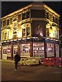
Ale Trail
This is the Royal Oak in Tabard St Southwark, Harveys Flagship tied house in London. It is on many a dedicated ale fans pilgrimage trail. In this geographer's humble opinion one of the finest boozers in town. It has won the local Camra Branch pub of the year on numerous occasions. The beer is superbly kept and they serve a traditional steak and kidney pud that is hard to beat. If you are more interested in history than beer try Image Take a look at it in daylight at Image
Image: © Glyn Baker
Taken: 30 Nov 2006
0.02 miles
8
Southwark Telephone Exchange
Situated in Nebraska Street, at the corner with Great Dover Street, this TE used to have HOP numbers until the late 1960s. Now it has 0207-234,357,378,397,403,407 and 939 numbers. Its postcode is SE1 4LT.
Image: © David Hillas
Taken: 11 Nov 2008
0.03 miles
9
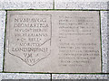
Site of a historic find
This information plaque is set into the pavement of Empire Square Image and records the archaeological find of "the earliest known monumental inscription to name London".
Image: © Stephen Craven
Taken: 7 Oct 2013
0.04 miles
10
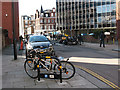
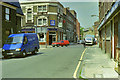
Silvester Street, Southwark
A short one-way side street connecting Tabard Street and Great Dover Street, it appears to be used mainly for car, motorcycle and bicycle parking.
Image: © Stephen Craven
Taken: 2 Mar 2010
0.05 miles