IMAGES TAKEN NEAR TO
Cole Street, LONDON, SE1 4LE
Introduction
This page details the photographs taken nearby to Cole Street, SE1 4LE by members of the Geograph project.
The Geograph project started in 2005 with the aim of publishing, organising and preserving representative images for every square kilometre of Great Britain, Ireland and the Isle of Man.

There are currently over 7.5m images from over14,400 individuals and you can help contribute to the project by visiting https://www.geograph.org.uk
Image Map
Images are licensed for reuse under creativecommons.org/licenses/by-sa/2.0
Notes
- Clicking on the map will re-center to the selected point.
- The higher the marker number, the further away the image location is from the centre of the postcode.
Image Listing (493 Images Found)
Images are licensed for reuse under creativecommons.org/licenses/by-sa/2.0
Image
Details
Distance
1
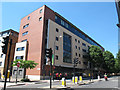
Apartments, Great Dover Street
A recent apartment block on the corner of Great Dover Street (A2, foreground) and Globe Street. The ground floor is occupied by the charity Carers UK.
Image: © Stephen Craven
Taken: 24 Jul 2012
0.01 miles
2
Globe Street, Southwark
Despite the name this street is unconnected with the Globe Theatre. There is a large plaque on the wall that reads: "C. Wallin & Co. Ltd. - Tin-Box Makers - Globe St. Works"
Image: © Stephen Craven
Taken: 20 Mar 2010
0.02 miles
3
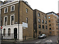
Cole Street
This area of Bermondsey was once quite industrial, and although all these buildings to the left now appear to be housing, they retain their industrial-architectural character. The building on the right is much more recent Image
Image: © Stephen Craven
Taken: 24 Jul 2012
0.02 miles
4
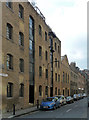
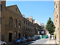
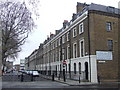
Cole Street
An atmospheric little street retaining a sense of its industrial past, as long as one doesn't look at the redeveloped other side.
The listing dates the near warehouse (now flats) to 1826-27. Grade II listed.
Image: © Stephen Richards
Taken: 6 May 2013
0.02 miles
5
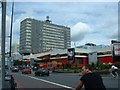
Elephant & Castle Shopping Centre
The 1960s Elephant & Castle Shopping Centre, soon to be demolished.
Image: © GaryReggae
Taken: 6 Aug 2005
0.02 miles
8
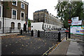
Trinity Street, SE1
The gate prevents through traffic from using Trinity Street, while still allowing cycles through.
The Trinity estate was developed in the 1820s. It takes its name from Trinity House, the authority responsible for lighthouses in England, Wales, the Channel Islands and Gibraltar. Trinity House developed the square and still owns the freehold to most of the properties.
The square is a Conservation Area, and most of the buildings are Grade II listed.
More information about the square can be found on the Trinity Newington Residents' Association website http://www.tnra.net/index.php?nuc=content&id=95
Image: © Malc McDonald
Taken: 9 Feb 2011
0.02 miles
9
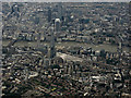
The City of London from the air
Taken from a Heathrow bound flight from Glasgow on a grey August day. Looking over Guys Hospital, The Shard and Tower Bridge to The City on the north bank of the Thames.
Image: © Thomas Nugent
Taken: 10 Aug 2016
0.02 miles
10
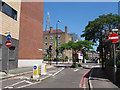
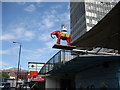
Point no-entry, Globe Street
This side road has been a point no-entry with access off Great Dover Street only for cycles, for some years. More recently a tree has been planted in the middle of the road to emphasise the restriction.
Image: © Stephen Craven
Taken: 24 Jul 2012
0.02 miles