IMAGES TAKEN NEAR TO
Falmouth Road, LONDON, SE1 4JX
Introduction
This page details the photographs taken nearby to Falmouth Road, SE1 4JX by members of the Geograph project.
The Geograph project started in 2005 with the aim of publishing, organising and preserving representative images for every square kilometre of Great Britain, Ireland and the Isle of Man.

There are currently over 7.5m images from over14,400 individuals and you can help contribute to the project by visiting https://www.geograph.org.uk
Image Map
Images are licensed for reuse under creativecommons.org/licenses/by-sa/2.0
Notes
- Clicking on the map will re-center to the selected point.
- The higher the marker number, the further away the image location is from the centre of the postcode.
Image Listing (331 Images Found)
Images are licensed for reuse under creativecommons.org/licenses/by-sa/2.0
Image
Details
Distance
2
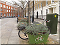
Plantlock cycle parking
These "plantlock" installations combine secure cycle parking with on-street planters. For context, see Image
Image: © Stephen Craven
Taken: 1 Feb 2013
0.01 miles
3
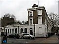
The Surrey Dispensary, Trinity Street
The Surrey Dispensary was opened in 1777 in Union Street, and was "a charitable institution for gratuitously attending lying-in women and providing medical and surgical aid to the poor inhabitants of the borough of Southwark and places adjacent."
It moved to this site off [Great] Dover Street in 1840.
Sources: http://www.british-history.ac.uk/report.aspx?compid=43045 ; http://openlibrary.org/b/OL7020351M/Rules_of_the_Surrey_Dispensary_Great_Dover_Street_Southwark_S.E.
Image: © Stephen Craven
Taken: 20 Mar 2010
0.01 miles
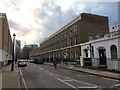
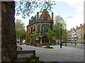
4
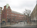
Trinity Street pedestrianised
The south-eastern end of Trinity Street was pedestrianised around 2008, along with a barrier at the eastern corner of Trinity Square. Access is now for cycles only.
The large building in the background is King's College student accommodation - see Image
Image: © Stephen Craven
Taken: 20 Mar 2010
0.02 miles
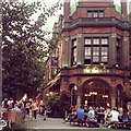
6
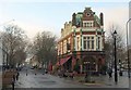
The Roebuck, SE1
The distinctive pub sits within the fork of Trinity Street (left) and Great Dover Street. It's described at http://www.britishlistedbuildings.co.uk/en-508137-the-roebuck-public-house-50-bermondsey as "in an eclectic free style with Jacobean, Dutch and Classical features" . On the left is a Giles Gilbert Scott telephone box, dating from 1927 http://www.britishlistedbuildings.co.uk/en-471425-k2-telephone-kiosk-at-junction-with-grea .
Image: © Derek Harper
Taken: 1 Feb 2011
0.02 miles
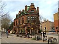
7
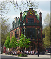
The Roebuck, Great Dover Street
Attractive late Victorian pub with a good array of gables, dormers and chimneys. Grade II listed.
Image: © Stephen Richards
Taken: 6 May 2013
0.02 miles
8
The Roebuck, Great Dover Street
The Roebuck is a distinctive grade II listed pub in the 'V' created by Great Dover Street and Trinity Street.
Image: © Stephen McKay
Taken: 30 Apr 2012
0.02 miles