IMAGES TAKEN NEAR TO
Trinity Church Square, LONDON, SE1 4HT
Introduction
This page details the photographs taken nearby to Trinity Church Square, SE1 4HT by members of the Geograph project.
The Geograph project started in 2005 with the aim of publishing, organising and preserving representative images for every square kilometre of Great Britain, Ireland and the Isle of Man.

There are currently over 7.5m images from over14,400 individuals and you can help contribute to the project by visiting https://www.geograph.org.uk
Image Map
Images are licensed for reuse under creativecommons.org/licenses/by-sa/2.0
Notes
- Clicking on the map will re-center to the selected point.
- The higher the marker number, the further away the image location is from the centre of the postcode.
Image Listing (486 Images Found)
Images are licensed for reuse under creativecommons.org/licenses/by-sa/2.0
Image
Details
Distance
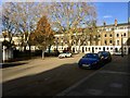
1
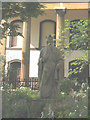
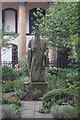
Statue of King Alfred, Trinity Church Square
The statue in the centre of the garden outside the Henry Wood Hall Image represents King Alfred (871-899). It was transferred there in 1822 from Westminster Hall, where it had occupied a recess for 450 years which makes it allegedly the oldest statue in London.
Image: © Stephen Craven
Taken: 16 Jun 2008
0.01 miles
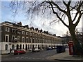
2
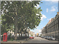
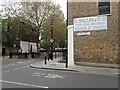
Trinity Church Square - north side
Formerly Great Suffolk Street East, this stretch of road forms the northern side of what is now Trinity Church Square. Although not fully pedestrianised it is very quiet because of traffic restrictions in the area. The area around the square is known as the Newington Trust Estate and more history can be found at http://www.tnra.net/estate/index.html
Image: © Stephen Craven
Taken: 16 Jun 2008
0.01 miles
3
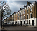
45-67 Trinity Church Square
The early-mid C19th developments in Trinity Church Square and surrounding streets are very well preserved. The terraces are handsome and uniform, in brick with stuccoed and rusticated ground floors and stuccoed window surrounds. The houses are generally of three storeys plus basements and two bays wide. These were built c1827. Grade II listed.
Image: © Stephen Richards
Taken: 6 May 2013
0.02 miles
4
Cole Street
This area of Bermondsey was once quite industrial, and although all these buildings to the left now appear to be housing, they retain their industrial-architectural character. The building on the right is much more recent Image
Image: © Stephen Craven
Taken: 24 Jul 2012
0.02 miles
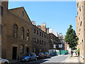
5
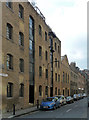
Cole Street
An atmospheric little street retaining a sense of its industrial past, as long as one doesn't look at the redeveloped other side.
The listing dates the near warehouse (now flats) to 1826-27. Grade II listed.
Image: © Stephen Richards
Taken: 6 May 2013
0.02 miles
7
Trinity Church Square, Newington, Southwark
Image: © Brian Whittle
Taken: 30 Nov 2017
0.02 miles
8
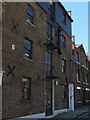
Cole Street - detail
For context see Image To emphasise the point made there about industrial-architectural character, this is a former hoist arrangement for a warehouse.
Image: © Stephen Craven
Taken: 24 Jul 2012
0.02 miles
9
Statue of King Alfred
Trinity Church Square.
Image: © Fernweh
Taken: 11 Aug 2014
0.03 miles
10
Looking along Trinity Street
This is part of the Trinity Village estate, one of the best-preserved areas of Georgian housing south of the Thames. The full history of the estate can be seen at https://www.trinityvillage.co.uk/village-history
On the opposite side of the road is a ghost sign which has clearly been repainted.
Image: © Marathon
Taken: 24 Oct 2020
0.03 miles