IMAGES TAKEN NEAR TO
Pardoner Street, LONDON, SE1 4DS
Introduction
This page details the photographs taken nearby to Pardoner Street, SE1 4DS by members of the Geograph project.
The Geograph project started in 2005 with the aim of publishing, organising and preserving representative images for every square kilometre of Great Britain, Ireland and the Isle of Man.

There are currently over 7.5m images from over14,400 individuals and you can help contribute to the project by visiting https://www.geograph.org.uk
Image Map
Images are licensed for reuse under creativecommons.org/licenses/by-sa/2.0
Notes
- Clicking on the map will re-center to the selected point.
- The higher the marker number, the further away the image location is from the centre of the postcode.
Image Listing (291 Images Found)
Images are licensed for reuse under creativecommons.org/licenses/by-sa/2.0
Image
Details
Distance
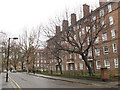
1
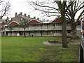
Tatsfield House, Pardoner Street
One of several housing blocks named after Surrey towns, one of many streets in the area named after themes in Chaucer's "Canterbury Tales". See also Image
Image: © Stephen Craven
Taken: 20 Mar 2010
0.01 miles
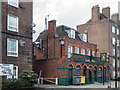
2
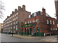
Leo's Den nursery, Law Street
The nursery opened in March 2009 in a pub that had most recently been the Ruse Too Bar.
Image: © Stephen Craven
Taken: 20 Mar 2010
0.03 miles
3
Housing on Manciple Street (backs)
The back of one of several similar blocks of housing on Manciple Street (itself one of many streets in the area named after themes in Chaucer's "Canterbury Tales").
Image: © Stephen Craven
Taken: 20 Mar 2010
0.03 miles
4
Leo's Den Nursery, Law Street, London SE1
This former public house is now used as a day nursery.
Image: © Christine Matthews
Taken: 8 Mar 2015
0.04 miles
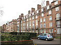
5
Manciple Street, Southwark
One of many streets in the area named after themes in Chaucer's "Canterbury Tales". According to Wikipedia, a manciple was in charge of the purchase and storage of food. It is an area of high-density residential housing, mostly belonging to Southwark Council. See also Image
Image: © Stephen Craven
Taken: 20 Mar 2010
0.04 miles
6
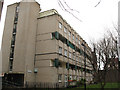
Dorking House, Pardoner Street, Southwark
One of several housing blocks named after Surrey towns, one of many streets in the area named after themes in Chaucer's "Canterbury Tales". There is a date 1965 above the door in the end of the block.
Image: © Stephen Craven
Taken: 20 Mar 2010
0.04 miles
7
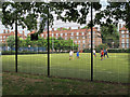
Tabard Gardens, football cage
Sports facilities in the park include this football pitch on an "all weather" surface, behind a high cage.
Image: © Stephen Craven
Taken: 23 Aug 2013
0.05 miles
8
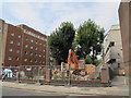
Demolition site on Law Street
The building being demolished was a single storey one, probably a utility building of some sort. There was no previous close-up of it on this site although it appears in the background of Image
Image: © Stephen Craven
Taken: 23 Aug 2013
0.06 miles
9
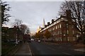
Weston Street
Looking along Weston Street from the junction with Law Street.
Image: © DS Pugh
Taken: 9 Dec 2016
0.06 miles
10
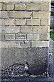
Benchmark on Chartham House, Weston Street
Ordnance Survey cut mark benchmark described on the Bench Mark Database at http://www.bench-marks.org.uk/bm37856
Image: © Roger Templeman
Taken: 6 May 2011
0.06 miles