IMAGES TAKEN NEAR TO
Weston Street, LONDON, SE1 4DH
Introduction
This page details the photographs taken nearby to Weston Street, SE1 4DH by members of the Geograph project.
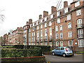
The Geograph project started in 2005 with the aim of publishing, organising and preserving representative images for every square kilometre of Great Britain, Ireland and the Isle of Man.

There are currently over 7.5m images from over14,400 individuals and you can help contribute to the project by visiting https://www.geograph.org.uk
Image Map
Images are licensed for reuse under creativecommons.org/licenses/by-sa/2.0
Notes
- Clicking on the map will re-center to the selected point.
- The higher the marker number, the further away the image location is from the centre of the postcode.
Image Listing (360 Images Found)
Images are licensed for reuse under creativecommons.org/licenses/by-sa/2.0
Image
Details
Distance
1
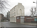
Weston Street - Pizza Planet
A closed pizza takeaway outlet in a building that looks to predate the mainly 20th century housing in the area.
Image: © Stephen Craven
Taken: 20 Mar 2010
0.02 miles
2
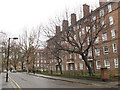
Manciple Street, Southwark
One of many streets in the area named after themes in Chaucer's "Canterbury Tales". According to Wikipedia, a manciple was in charge of the purchase and storage of food. It is an area of high-density residential housing, mostly belonging to Southwark Council. See also Image
Image: © Stephen Craven
Taken: 20 Mar 2010
0.03 miles
3
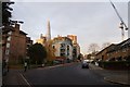
Along Weston Street
Elim Street is on the right.
Image: © DS Pugh
Taken: 9 Dec 2016
0.04 miles
4
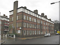
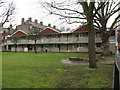
Weston Street, Elim Estate
One of the many low-rise housing blocks in this area of Southwark.
Image: © Stephen Craven
Taken: 20 Mar 2010
0.05 miles
5
Housing on Manciple Street (backs)
The back of one of several similar blocks of housing on Manciple Street (itself one of many streets in the area named after themes in Chaucer's "Canterbury Tales").
Image: © Stephen Craven
Taken: 20 Mar 2010
0.05 miles
6
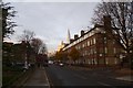
Weston Street
Looking along Weston Street from the junction with Law Street.
Image: © DS Pugh
Taken: 9 Dec 2016
0.06 miles
7
Bike docking station on Long Lane
There was only one bike left at lunchtime.
Image: © Stephen Craven
Taken: 9 Aug 2012
0.06 miles
8
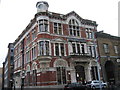
Bermondsey Leather Market, Bermondsey, SE1
Image: © John Goodall
Taken: 11 Jan 2006
0.06 miles
9
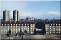
View north-east from roof, 165 Gt Dover St
Looking towards Tower Bridge. In the foreground is the recreational end of Tabard Gardens.
Image: © Robin Webster
Taken: Unknown
0.06 miles
10
Tatsfield House, Pardoner Street
One of several housing blocks named after Surrey towns, one of many streets in the area named after themes in Chaucer's "Canterbury Tales". See also Image
Image: © Stephen Craven
Taken: 20 Mar 2010
0.06 miles