IMAGES TAKEN NEAR TO
County Street, LONDON, SE1 4AD
Introduction
This page details the photographs taken nearby to County Street, SE1 4AD by members of the Geograph project.
The Geograph project started in 2005 with the aim of publishing, organising and preserving representative images for every square kilometre of Great Britain, Ireland and the Isle of Man.

There are currently over 7.5m images from over14,400 individuals and you can help contribute to the project by visiting https://www.geograph.org.uk
Image Map
Images are licensed for reuse under creativecommons.org/licenses/by-sa/2.0
Notes
- Clicking on the map will re-center to the selected point.
- The higher the marker number, the further away the image location is from the centre of the postcode.
Image Listing (245 Images Found)
Images are licensed for reuse under creativecommons.org/licenses/by-sa/2.0
Image
Details
Distance
1
Recovery Chapel, County Street, Southwark
The Recovery Chapel International (founded 2007) meets in this building in County Street.
Image: © Stephen Craven
Taken: 20 Mar 2010
0.01 miles
2
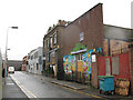
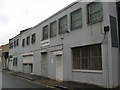
County Street, Southwark
This end of County Street is a dead-end off Harper Road. The wall on the left is the boundary of the Globe Academy - see Image On the right are light industrial premises.
Image: © Stephen Craven
Taken: 20 Mar 2010
0.01 miles
3
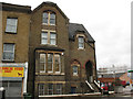
195 New Kent Road
This property looks as if it might have originally been the vicarage for St Andrew's church that stood just to the right of it - see Image It appears presently to be the home of a drug rehabilitation charity.
Image: © Stephen Craven
Taken: 20 Mar 2010
0.02 miles
4

Defences of the Globe Academy
It is unfortunate that security concerns mean that contemporary schools are hidden behind defences that would not be out of place on a Roman fort: tall brick walls surmounted by high fences, in front of high earth mounds that conceal the actual school buildings.
The Globe Academy http://www.globeacademy.org/ opened in 2008.
Image: © Stephen Craven
Taken: 20 Mar 2010
0.04 miles
5
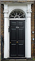
Detail of 154 New Kent Road
Doorcase with "attached columns with foliage capitals supporting entablature with medallions and dentil cornice" and radial fanlight.
Wider view: Image
Image: © Stephen Richards
Taken: 6 May 2013
0.04 miles
6
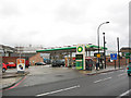
BP filling station, New Kent Road
The filling station is on the corner of New Kent Road and Theobald Street. Unleaded and petrol and diesel were both advertised at 118.9 pence per litre, after a steep price rise in early 2010 (a year earlier it was around 90 pence).
The filling station stands on the site of the former St Andrew's Church, Newington, which stood here from 1876-1956. The church hall remained but was demolished c 1980, following a fire. (Information supplied by James Manning).
Image: © Stephen Craven
Taken: 20 Mar 2010
0.05 miles
7
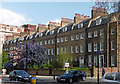
154-170 New Kent Road
A handsome late C18th terrace of nine houses, each of three storeys plus basement and attic in three bays (Image]), and possessing a decorative wooden doorcase (Image]). Grade II listed.
Image: © Stephen Richards
Taken: 6 May 2013
0.05 miles
8
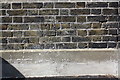
Benchmark on wall of access drive to the Globe Academy
Ordnance Survey cut mark benchmark described on the Bench Mark Database at http://www.bench-marks.org.uk/bm37845
Image: © Roger Templeman
Taken: 6 May 2011
0.05 miles
9
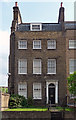
170 New Kent Road
One of the end houses in this good late C18th terrace (Image]). The doorcase (Image]) and rubbed brick flat arches to the windows are the only remotely decorative elements and yet the proportions and homely brick make for a satisfying facade.
Wider view: Image
Image: © Stephen Richards
Taken: 6 May 2013
0.05 miles
10
Kwik-Fit, New Kent Road
A motor repair franchise.
Image: © Stephen Craven
Taken: 20 Mar 2010
0.06 miles