IMAGES TAKEN NEAR TO
Maltings Place, Tower Bridge Road, LONDON, SE1 3LJ
Introduction
This page details the photographs taken nearby to Maltings Place, Tower Bridge Road, SE1 3LJ by members of the Geograph project.
The Geograph project started in 2005 with the aim of publishing, organising and preserving representative images for every square kilometre of Great Britain, Ireland and the Isle of Man.

There are currently over 7.5m images from over14,400 individuals and you can help contribute to the project by visiting https://www.geograph.org.uk
Image Map
Images are licensed for reuse under creativecommons.org/licenses/by-sa/2.0
Notes
- Clicking on the map will re-center to the selected point.
- The higher the marker number, the further away the image location is from the centre of the postcode.
Image Listing (568 Images Found)
Images are licensed for reuse under creativecommons.org/licenses/by-sa/2.0
Image
Details
Distance
1
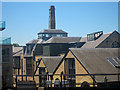
Brunswick Maltings & Factory Buildings
Converted Grade II listed maltings and factory building beside the railway.
http://list.english-heritage.org.uk/resultsingle.aspx?uid=1385821 http://list.english-heritage.org.uk/resultsingle.aspx?uid=1385822 http://list.english-heritage.org.uk/resultsingle.aspx?uid=1385823 http://list.english-heritage.org.uk/resultsingle.aspx?uid=1385824 http://list.english-heritage.org.uk/resultsingle.aspx?uid=1385825 http://list.english-heritage.org.uk/resultsingle.aspx?uid=1385826
Image: © Oast House Archive
Taken: 26 Jun 2011
0.01 miles
2
Brunswick Maltings & Factory Buildings
Converted Grade II listed maltings and factory building beside the railway.
http://list.english-heritage.org.uk/resultsingle.aspx?uid=1385821 http://list.english-heritage.org.uk/resultsingle.aspx?uid=1385822 http://list.english-heritage.org.uk/resultsingle.aspx?uid=1385823 http://list.english-heritage.org.uk/resultsingle.aspx?uid=1385824 http://list.english-heritage.org.uk/resultsingle.aspx?uid=1385825 http://list.english-heritage.org.uk/resultsingle.aspx?uid=1385826
Image: © Oast House Archive
Taken: 26 Jun 2011
0.01 miles
5
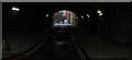
View down Roper Lane
Looking south-southeast through the tunnel.
Image: © Robert Lamb
Taken: 27 Jan 2019
0.03 miles
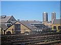
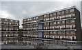
6
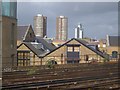
Buildings near London Bridge
A view from a train approaching London Bridge station. In the foreground beyond the tracks is Maltings Place, with flat conversions. The highrise blocks are Simla House and Burwash House, in Image; the further block is at Empire Square West.
Image: © Derek Harper
Taken: 20 May 2006
0.03 miles
7
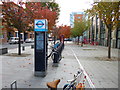
Bermondsey, bicycle hire
Barclays Cycle Hire stands on Tanner Street: http://www.tfl.gov.uk/roadusers/cycling/14808.aspx
Image: © Mike Faherty
Taken: 13 Oct 2012
0.03 miles
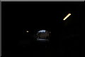
8
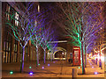
Blue and Green Trees, Tower Bridge Road
Pairs of spotlights highlight these two rows of trees along Tower Bridge Road.
Beyond the Red Telephone Box, is a Barclays Bike Docking Station and hire-bikes.
Further back is the railway bridge over the road and footpath carrying the multiple railway lines (left) to London Bridge Station.
Image: © David Anstiss
Taken: 18 Dec 2011
0.04 miles
9
View along Brunswick Close from Druid Street
Looking south-southwest through the tunnel.
Image: © Robert Lamb
Taken: 27 Jan 2019
0.04 miles
10
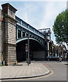
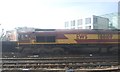
Bridge, Tower Bridge Road
The railway approach to London Bridge Station slices through the area generating a lengthy viaduct.
Image: © Stephen Richards
Taken: 26 May 2013
0.04 miles