IMAGES TAKEN NEAR TO
Weston Street, LONDON, SE1 3GX
Introduction
This page details the photographs taken nearby to Weston Street, SE1 3GX by members of the Geograph project.
The Geograph project started in 2005 with the aim of publishing, organising and preserving representative images for every square kilometre of Great Britain, Ireland and the Isle of Man.

There are currently over 7.5m images from over14,400 individuals and you can help contribute to the project by visiting https://www.geograph.org.uk
Image Map
Images are licensed for reuse under creativecommons.org/licenses/by-sa/2.0
Notes
- Clicking on the map will re-center to the selected point.
- The higher the marker number, the further away the image location is from the centre of the postcode.
Image Listing (1180 Images Found)
Images are licensed for reuse under creativecommons.org/licenses/by-sa/2.0
Image
Details
Distance
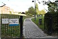
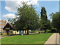
2
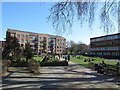
Guy Street Park
Originally open fields, the land on which most of Guy Street Park stands belonged to Guy's Hospital in the 18th century. It was used as a burial ground until it was closed and leased to a builder. By the end of the 19th century, Bermondsey Vestry needed a public recreation ground for its inhabitants who were living in very overcrowded conditions. The land was purchased with the help of the London County Council and others. It was opened on March 30th 1899 and called Nelson Recreation Ground. Despite War damage, the park was refurbished and extended. By the 1990s it had become very run down and local people formed the Friends of Guy Street Park. The new Guy Street Park opened in April 2003. The flats beyond are in Guy Street Park.
Image: © Marathon
Taken: 14 Oct 2011
0.02 miles
3
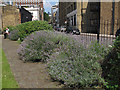
Guy Street Park - lavender
A bed of lavender at the eastern end of the park.
Image: © Stephen Craven
Taken: 9 Aug 2012
0.03 miles
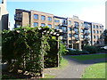
4

London : Southwark - London Scenery from The Shard
Looking towards some apartment buildings which are overlooked by The Shard.
Image: © Lewis Clarke
Taken: 15 Jan 2016
0.03 miles
5
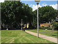
Guy Street Park - path
The main pedestrian route east-west through the park.
Image: © Stephen Craven
Taken: 9 Aug 2012
0.04 miles
6
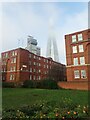
The Shard from Leathermarket Gardens
The name of Leathermarket Gardens comes from the historic leather markets and tanneries nearby. The park was laid out in the 1930s. It is a popular sitting out area for local workers.
After a foggy start to the day, the top of The Shard was still covered in mist. In the foreground are the Guinness Trust Buildings - see https://www.geograph.org.uk/photo/6651093
Image: © Marathon
Taken: 7 Dec 2020
0.04 miles
7
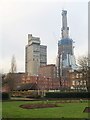
Buildings in Bermondsey
Looking across Leathermarket Gardens to buildings on Kirby Grove, with Snowsfields Primary School on the right. Renzo Piano's Shard London Bridge is a-building behind (to the right of Guy's Tower, in Image) - perhaps it will become prettier as it becomes the tallest building in Europe.
Image: © Derek Harper
Taken: 1 Feb 2011
0.04 miles
8
Guy Street Park
On this unseasonally warm Spring day it was being used mainly by office workers for some lunchtime sunshine.
Image: © Stephen Craven
Taken: 27 Mar 2012
0.04 miles
9
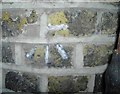
Benchmark on #72 Weston Street
Ordnance Survey cut mark benchmark described on the Bench Mark Database at http://www.bench-marks.org.uk/bm37121
Image: © Roger Templeman
Taken: 16 Feb 2011
0.04 miles
10
Leathermarket Gardens - Bermondsey Village Hall
Within this small park is a building called the Village Hall, although a less village-like place could hardly be imagined.
Image: © Stephen Craven
Taken: 9 Aug 2012
0.04 miles