IMAGES TAKEN NEAR TO
Tooley Street, LONDON, SE1 2UD
Introduction
This page details the photographs taken nearby to Tooley Street, SE1 2UD by members of the Geograph project.
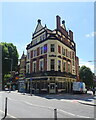
The Geograph project started in 2005 with the aim of publishing, organising and preserving representative images for every square kilometre of Great Britain, Ireland and the Isle of Man.

There are currently over 7.5m images from over14,400 individuals and you can help contribute to the project by visiting https://www.geograph.org.uk
Image Map
Images are licensed for reuse under creativecommons.org/licenses/by-sa/2.0
Notes
- Clicking on the map will re-center to the selected point.
- The higher the marker number, the further away the image location is from the centre of the postcode.
Image Listing (2392 Images Found)
Images are licensed for reuse under creativecommons.org/licenses/by-sa/2.0
Image
Details
Distance
1
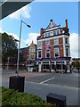
The Bridge Lounge and Dining Room, Tooley Street
Image: © PAUL FARMER
Taken: 1 Jul 2012
0.01 miles
2
Former historic Pub
Tooley Street, South Bank
Image: © Anthony O'Neil
Taken: 14 Oct 2017
0.01 miles
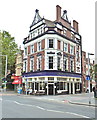
3
The Bridge Lounge
This pub is on the Corner of Tooley Street and Druid Street.
Image: © Oxyman
Taken: 27 Sep 2007
0.01 miles
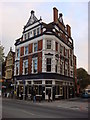
4
The Bridge Lounge, Tooley Street
Victorian pub with a lively roofline, dated 1897 in the gable.
It has a slender gabled neighbour, no. 188.
Image: © Stephen Richards
Taken: 26 May 2013
0.01 miles
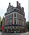
5
The Two Bridges Ale House & Kitchen
On Tooley Street.
Image: © JThomas
Taken: 20 Jun 2022
0.01 miles
6
Barclays Cycle Hire Docking Station, Tooley Street
Image: © PAUL FARMER
Taken: 20 May 2011
0.01 miles
7
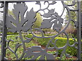
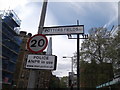
Gate detail, Potters Fields Park, Tooley Street SE1
Image: © Robin Sones
Taken: 3 May 2018
0.02 miles
8
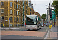
Tooley Street
A tourist coach makes its way towards Tower Bridge Road past the junction with Druid Street. Please compare this photo with Image taken in 1976. Apart from the relocation of the crossing and the removal of the bus stand, the buildings opposite have had a major clean. Southwark Towers, visible in the original photo, has been demolished to make way for The Shard, a new development which is just becoming visible above the brick built apartments.
Image: © Martin Addison
Taken: 22 Oct 2010
0.02 miles
10
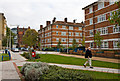
St. Olaves Estate
Located on Druid Street North, the area has been partially pedestrianised making it a 'homezone' with a 'pocket park' to quote Southwark Council's website. Previously it had been a popular rat run with all the attendant risks to the safety of children living on the estate.
Image: © Martin Addison
Taken: 22 Oct 2010
0.02 miles