IMAGES TAKEN NEAR TO
Lant Street, LONDON, SE1 1RB
Introduction
This page details the photographs taken nearby to Lant Street, SE1 1RB by members of the Geograph project.
The Geograph project started in 2005 with the aim of publishing, organising and preserving representative images for every square kilometre of Great Britain, Ireland and the Isle of Man.

There are currently over 7.5m images from over14,400 individuals and you can help contribute to the project by visiting https://www.geograph.org.uk
Image Map
Images are licensed for reuse under creativecommons.org/licenses/by-sa/2.0
Notes
- Clicking on the map will re-center to the selected point.
- The higher the marker number, the further away the image location is from the centre of the postcode.
Image Listing (646 Images Found)
Images are licensed for reuse under creativecommons.org/licenses/by-sa/2.0
Image
Details
Distance
1
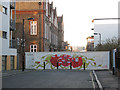
Lant Street barricaded
A wooden hoarding blocking off the western end of Lant Street, presumably for a building development.
Image: © Stephen Craven
Taken: 4 Mar 2010
0.02 miles
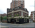
2
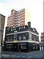
The Gladstone Arms, Lant Street, Southwark (1)
This appears to be a traditional 19th century city pub. It is on the corner of Lant Street and Sanctuary Street.
Image: © Stephen Craven
Taken: 4 Mar 2010
0.03 miles
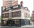
3
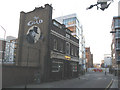
The Gladstone Arms, Lant Street, Southwark (2)
The eastern end of this pub also seen in Image is labelled "The Glad", presumably to attract younger customers.
Image: © Stephen Craven
Taken: 4 Mar 2010
0.03 miles
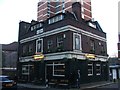
5
The Gladstone Arms, Lant Street
The pub looks early C20th. It has weathered many storms but may yet be sunk by filthy lucre in the form or developers who want to replace it with a block of flats. An application for listing has been rejected but the pub, an active music venue, has been registered as an 'asset of community value' under the Localism Act so the money men have a fight on their hands.
Image: © Stephen Richards
Taken: 5 May 2013
0.03 miles
6
"The Gladstone Arms", Lant Street, Southwark
Under threat public house celebrated at this http://www.spectator.co.uk/2015/08/the-pub-that-shows-what-londons-losing/.
Image: © Jim Osley
Taken: 13 May 2016
0.03 miles
7
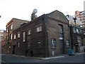
Industrial building on Sanctuary Street, Southwark
This anonymous brick building on the corner of Sanctuary Street and Vine Yard looks to have been in industrial use originally. This part of London was heavily industrial in the 19th century, though now mainly residential and commercial.
Image: © Stephen Craven
Taken: 4 Mar 2010
0.04 miles
8
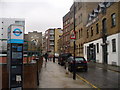
Lant Street, The Borough
Wet day in London where the old brick pubs and warehouses jostle for space with modern technology and flats.
Image: © Colin Smith
Taken: 18 Mar 2011
0.04 miles
9
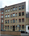
59 Lant Street
Rather a good Victorian warehouse displaying polychromatic brickwork.
Now flats.
Image: © Stephen Richards
Taken: 5 May 2013
0.05 miles
