IMAGES TAKEN NEAR TO
Newburn Street, LONDON, SE11 5PT
Introduction
This page details the photographs taken nearby to Newburn Street, SE11 5PT by members of the Geograph project.
The Geograph project started in 2005 with the aim of publishing, organising and preserving representative images for every square kilometre of Great Britain, Ireland and the Isle of Man.

There are currently over 7.5m images from over14,400 individuals and you can help contribute to the project by visiting https://www.geograph.org.uk
Image Map
Images are licensed for reuse under creativecommons.org/licenses/by-sa/2.0
Notes
- Clicking on the map will re-center to the selected point.
- The higher the marker number, the further away the image location is from the centre of the postcode.
Image Listing (241 Images Found)
Images are licensed for reuse under creativecommons.org/licenses/by-sa/2.0
Image
Details
Distance
1
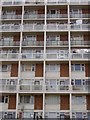
Waylett House, Vauxhall
Symmetrical features of this 1970s tower block in Vauxhall.
Image: © Matt Baines
Taken: 1 Jul 2004
0.01 miles
2
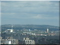
View of southeast London from Altitude 360
Taken whilst attending a London Photo Walk, this is a view of southeast London from the viewing gallery of Altitude 360 on the top floor of the Millbank Tower looking southeast.
Image: © Robert Lamb
Taken: 29 Aug 2010
0.04 miles
3
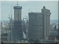
Close-up of the Shard from Altitude 360
Taken whilst attending a London Photo Walk, this is a view of the Shard taken from the viewing gallery of Altitude 360 on the top floor of the Millbank Tower looking southeast.
Image: © Robert Lamb
Taken: 29 Aug 2010
0.04 miles
4
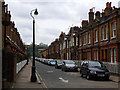
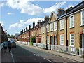
Courtenay Street
A street of Victorian terrace houses in Kennington.
Image: © Stephen Craven
Taken: 17 Aug 2013
0.05 miles
7
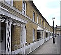
Lambeth: Woodstock Court, Newburn Street
Originally these were almshouses, thought to be of sufficient importance to have been opened by the Prince of Wales, (the future Edward VIII) in 1914.
Image: © Dr Neil Clifton
Taken: 23 Jun 2012
0.06 miles
8
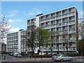
Vauxhall Gardens Estate, Kennington Lane
These two blocks, perhaps influenced by Le Corbusier, are Duffell and Waylett Houses. My thanks to Edmund Bird who tells me that the estate was built in 1964-65 to the designs of Howes & Jackman for the London County Council.
Image: © Stephen Richards
Taken: 15 Apr 2012
0.07 miles
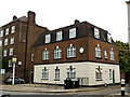
9
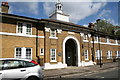
The Duchy Arms, closed
This pub at the northern end of Courtenay Street took its name from the Duchy of Cornwall, which still owns much of the land around Kennington.
Image: © Stephen Craven
Taken: 17 Aug 2013
0.07 miles
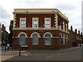
10
The Rising Sun
This building on the corner of Dolland Street and Vauxhall Street still had a pub sign outside but did not look like a functioning pub.
Image: © Stephen Craven
Taken: 17 Aug 2013
0.08 miles