IMAGES TAKEN NEAR TO
Newburn Street, LONDON, SE11 5PL
Introduction
This page details the photographs taken nearby to Newburn Street, SE11 5PL by members of the Geograph project.
The Geograph project started in 2005 with the aim of publishing, organising and preserving representative images for every square kilometre of Great Britain, Ireland and the Isle of Man.

There are currently over 7.5m images from over14,400 individuals and you can help contribute to the project by visiting https://www.geograph.org.uk
Image Map
Images are licensed for reuse under creativecommons.org/licenses/by-sa/2.0
Notes
- Clicking on the map will re-center to the selected point.
- The higher the marker number, the further away the image location is from the centre of the postcode.
Image Listing (221 Images Found)
Images are licensed for reuse under creativecommons.org/licenses/by-sa/2.0
Image
Details
Distance
1
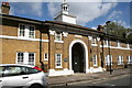
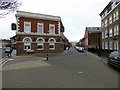
Lambeth: Woodstock Court, Newburn Street
Originally these were almshouses, thought to be of sufficient importance to have been opened by the Prince of Wales, (the future Edward VIII) in 1914.
Image: © Dr Neil Clifton
Taken: 23 Jun 2012
0.02 miles
2
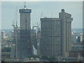
Close-up of the Shard from Altitude 360
Taken whilst attending a London Photo Walk, this is a view of the Shard taken from the viewing gallery of Altitude 360 on the top floor of the Millbank Tower looking southeast.
Image: © Robert Lamb
Taken: 29 Aug 2010
0.02 miles
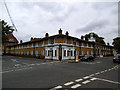
3
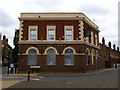
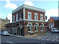
The Duchy Arms, closed
This pub at the northern end of Courtenay Street took its name from the Duchy of Cornwall, which still owns much of the land around Kennington.
Image: © Stephen Craven
Taken: 17 Aug 2013
0.03 miles
5
The Duchy Arms and (to the right) Courteney Street
Image: © PAUL FARMER
Taken: 23 Feb 2018
0.03 miles
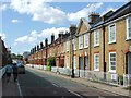
7
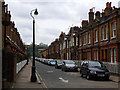
Courtenay Street
A street of Victorian terrace houses in Kennington.
Image: © Stephen Craven
Taken: 17 Aug 2013
0.04 miles
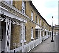
8
Woodstock Court
This building on Newburn Street, shown as a "hospital" on the street map is (or at least originally was) sheltered accommodation for employees of the Duchy of Cornwall, which owns much of the land around Kennington. So, a hospital in an old sense of the word. Listed grade 2* (list entry number 1320423).
Image: © Stephen Craven
Taken: 17 Aug 2013
0.05 miles
10

Newburn Street, Lambeth
The building was put up in 1914 by the Duchy of Cornwall.
Image: © David Howard
Taken: 27 Mar 2022
0.05 miles