IMAGES TAKEN NEAR TO
Randall Road, LONDON, SE11 5JR
Introduction
This page details the photographs taken nearby to Randall Road, SE11 5JR by members of the Geograph project.
The Geograph project started in 2005 with the aim of publishing, organising and preserving representative images for every square kilometre of Great Britain, Ireland and the Isle of Man.

There are currently over 7.5m images from over14,400 individuals and you can help contribute to the project by visiting https://www.geograph.org.uk
Image Map
Images are licensed for reuse under creativecommons.org/licenses/by-sa/2.0
Notes
- Clicking on the map will re-center to the selected point.
- The higher the marker number, the further away the image location is from the centre of the postcode.
Image Listing (448 Images Found)
Images are licensed for reuse under creativecommons.org/licenses/by-sa/2.0
Image
Details
Distance
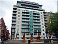
1
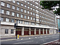
London Fire Brigade Headquarters, London SE1
The London Fire Brigade Headquarters building is on the Albert Embankment.
Image: © Christine Matthews
Taken: 10 Sep 2010
0.03 miles
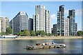
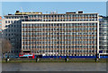
2
Hampton House, Albert Embankment
Part of the wall of offices along Albert Embankment.
Image: © N Chadwick
Taken: 25 Aug 2010
0.04 miles
3
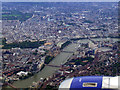
Westminster and the Thames from the air
Millbank Tower, the Houses of Parliament, the London Eye and Waterloo railway station are the major landmarks on view from this Heathrow bound flight from Glasgow.
Image: © Thomas Nugent
Taken: 29 Aug 2011
0.04 miles
4

Westminster and Whitehall from the air
Looking over Lambeth Bridge to the Palace of Westminster, up Whitehall to Trafalgar Square and Charing Cross Road beyond.
Image: © Thomas Nugent
Taken: 9 Oct 2011
0.04 miles
5
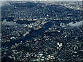
Central London from the air
Part of The Oval cricket ground is visible at the bottom of the photo which also shows the Houses of Parliament, the London Eye, Waterloo railway station and the following Thames bridges from left to right; Vauxhall, Lambeth, Westminster, Hungerford (railway) and Waterloo. Taken from a Heathrow bound flight from Glasgow.
Image: © Thomas Nugent
Taken: 18 Mar 2014
0.04 miles
7
Albert Embankment, SE1
Taken from Millbank.
Image: © Phillip Perry
Taken: 4 Aug 2008
0.04 miles
8
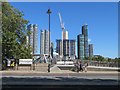
High Rise on the South Bank
Riverside living at Lambeth.
Image: © Des Blenkinsopp
Taken: 19 Jun 2024
0.04 miles
9
White Hart Dock, Albert Embankment, London SE1
These timber structures were inaugurated on 17 October 2009 as part of the programme to highlight the existence of White Hart Dock.
Image: © Christine Matthews
Taken: 10 Sep 2010
0.05 miles
10
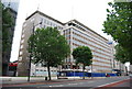
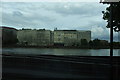
Hampton House, Albert Embankment
One of a series of post-war office blocks lining the southern stretch of Albert Embankment. Hampton was completed in 1956, the architect Frederick Gibberd, making it one of the first office blocks to be built following the lifting of the post-war austerity building restrictions in 1954. Banners advertise office space, but any tenant would have to fight their way through hoardings: it currently awaits demolition to be replaced by three towers designed by Norman Foster and Partners.
Image: © Stephen Richards
Taken: 7 Mar 2011
0.05 miles