IMAGES TAKEN NEAR TO
Tyers Street, LONDON, SE11 5HB
Introduction
This page details the photographs taken nearby to Tyers Street, SE11 5HB by members of the Geograph project.
The Geograph project started in 2005 with the aim of publishing, organising and preserving representative images for every square kilometre of Great Britain, Ireland and the Isle of Man.

There are currently over 7.5m images from over14,400 individuals and you can help contribute to the project by visiting https://www.geograph.org.uk
Image Map
Images are licensed for reuse under creativecommons.org/licenses/by-sa/2.0
Notes
- Clicking on the map will re-center to the selected point.
- The higher the marker number, the further away the image location is from the centre of the postcode.
Image Listing (319 Images Found)
Images are licensed for reuse under creativecommons.org/licenses/by-sa/2.0
Image
Details
Distance
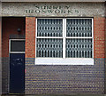
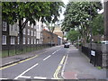
1
Former retail premises on Jonathan Street
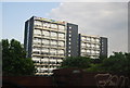
On the junction of Jonathan Street and Tyers Street.
In the background are blocks of housing, Vauxhall Gardens Estate.
Image: © David Anstiss
Taken: 20 Nov 2011
0.03 miles


9
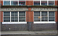
Mosaic ghost sign, Vauxhall
Former bedstead manufactury.
Image: © Jim Osley
Taken: 10 Jan 2014
0.07 miles