IMAGES TAKEN NEAR TO
Vauxhall Walk, LONDON, SE11 5EU
Introduction
This page details the photographs taken nearby to Vauxhall Walk, SE11 5EU by members of the Geograph project.
The Geograph project started in 2005 with the aim of publishing, organising and preserving representative images for every square kilometre of Great Britain, Ireland and the Isle of Man.

There are currently over 7.5m images from over14,400 individuals and you can help contribute to the project by visiting https://www.geograph.org.uk
Image Map
Images are licensed for reuse under creativecommons.org/licenses/by-sa/2.0
Notes
- Clicking on the map will re-center to the selected point.
- The higher the marker number, the further away the image location is from the centre of the postcode.
Image Listing (516 Images Found)
Images are licensed for reuse under creativecommons.org/licenses/by-sa/2.0
Image
Details
Distance
1
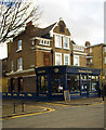
Tea House Theatre, Vauxhall
Conversion of a Victorian public house, the "Queen Anne" (closed 2010), said to have been the oldest strip pub in London.
Image: © Jim Osley
Taken: 10 Jan 2014
0.01 miles
3
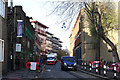
Vauxhall Walk
A van makes its way along the road past the Vauxhall Gardens Community Centre, aka The Spring.
Image: © Martin Addison
Taken: 2 Dec 2011
0.03 miles
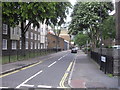

6
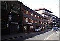
Offices in Vauxhall Walk
Picture taken looking toward Tanworth Street on the left
Image: © PAUL FARMER
Taken: 15 Mar 2009
0.04 miles

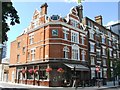
9
Queen Anne Public House Spring Gardens
Picture is taken from Glasshouse Walk, the pub is on the junction of Vauxhall Walk and Laud Street
Image: © PAUL FARMER
Taken: 15 Mar 2009
0.04 miles
