IMAGES TAKEN NEAR TO
Kennington Lane, LONDON, SE11 5DP
Introduction
This page details the photographs taken nearby to Kennington Lane, SE11 5DP by members of the Geograph project.
The Geograph project started in 2005 with the aim of publishing, organising and preserving representative images for every square kilometre of Great Britain, Ireland and the Isle of Man.

There are currently over 7.5m images from over14,400 individuals and you can help contribute to the project by visiting https://www.geograph.org.uk
Image Map (Loading...)


Getting Data...Please wait
Leaflet Map data © OpenStreetMap
Images are licensed for reuse under creativecommons.org/licenses/by-sa/2.0
Notes
- Clicking on the map will re-center to the selected point.
- The higher the marker number, the further away the image location is from the centre of the postcode.
Image Listing (192 Images Found)
Images are licensed for reuse under creativecommons.org/licenses/by-sa/2.0
Image
Details
Distance
2
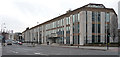
Edinburgh House, Kennington Lane
Office building dating, at a guess, from the 1970s. Long and low, but offset by vertical concrete strips separating the windows. Signage is low-key, but I believe it is currently occupied by the Metropolitan Police.
Image: © Stephen Richards
Taken: 12 Mar 2011
0.03 miles
4
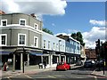
Kennington Road, late afternoon in February
KT on the sign is for Kennington Tandoori, an excellent Michelin listed restaurant, apparently a popular haunt of some MP's.
Image: © Trevor Harris
Taken: 13 Feb 2019
0.03 miles
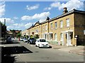
5
Kennington Lane looking towards Kennington Road
Image: © David Howard
Taken: 10 Dec 2013
0.03 miles
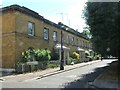
7
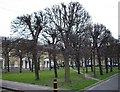
Courtenay Square
Picture taken from Cardigan Street
Image: © PAUL FARMER
Taken: 28 Feb 2009
0.04 miles
8
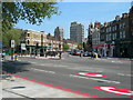
Kennington Lane meets Kennington Road
We are looking down Kennington Lane, towards the Elephant and Castle, which is not far from the 2 tower blocks. Note the red and white "C" logo -- it denotes that you are entering the congestion charge zone. The double red lines at the side of the road are not associated with that, they denote a "Red Route" with very strict parking controls.
Image: © Danny P Robinson
Taken: 11 May 2006
0.04 miles
9
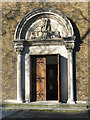
St Anselm, Kennington Cross, London SE11 - Doorway
Image: © John Salmon
Taken: 27 Feb 2005
0.04 miles